
Atlantic Hurricane Outlook – August 14, 2025: Erin strengthening over the central Atlantic
Tropical Storm Erin is organizing over the central Atlantic and could become a hurricane within 24 hours. A low-risk Gulf disturbance may bring rain to parts of NE Mexico and South Texas. U.S. impacts are limited to surf and rip currents.
TLDR Version; Click Here
Erin strengthening over the central Atlantic; low‑chance Gulf disturbance; U.S. impacts limited to surf and rip currents for now

Tropical Storm Erin continues to organize over the central tropical Atlantic and is forecast to become a hurricane within the next day and possibly a major hurricane this weekend. A separate weak disturbance near the southwest Gulf has low odds of development. No tropical cyclones are expected to affect the U.S. in the short term, but increasing surf and rip current hazards are likely along portions of the East Coast into next week.
Atlantic Basin Overview
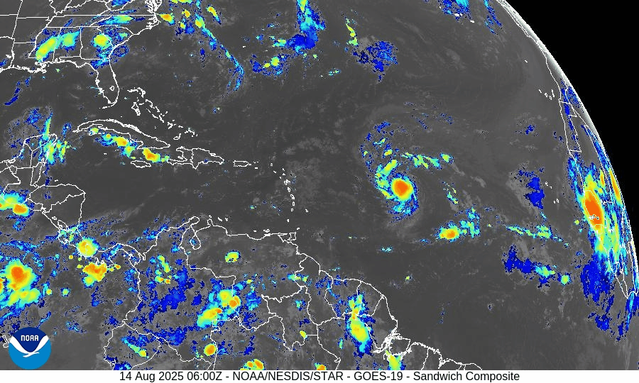
Tropical Storm Erin (central Atlantic):
Erin remains the only active named system. Hurricane Hunters are slated to sample the storm as it moves into a more favorable environment for intensification. Forecast guidance indicates hurricane strength by Friday and a risk of rapid intensification this weekend, with a track bending northwest and staying well east of the U.S. mainland.Current intensity snapshot:
Recent analyses place Erin over the central Atlantic with sustained winds near 50 mph as it organizes. Expect a steady strengthening trend over very warm waters.Swell & surf impacts:
Even with a track offshore, long‑period swells from Erin are expected to raise the risk of dangerous surf and rip currents along parts of the U.S. East Coast next week (Outer Banks and elsewhere). Coastal visitors should heed local beach forecasts.
Click Image For More Detail


Gulf of America (Mexico) & Caribbean
Southwest Gulf disturbance:
A weak, broad trough near the Bay of Campeche/Yucatán region will move west toward northeastern Mexico late week. NHC assigns low (20%) odds of development over the next 2–7 days; regardless, increased showers and a slight uptick in swells are possible near the lower Texas coast and northeast Mexico late Friday into Saturday.Rest of the Gulf & Caribbean:
Elsewhere, no organized disturbances. Typical trade‑wind showers continue in the Caribbean with seasonably warm seas and generally modest marine conditions.
GOES - GULF - August 14, 2025
GOES - Caribbean - August 14, 2025
Florida & Southeast U.S. Outlook
Florida (statewide):
A typical mid‑August pattern prevails—hot and humid with scattered afternoon thunderstorms driven by sea‑breeze collisions; storms are not tropical in origin. Coastal surf may gradually build this weekend into early next week from distant Erin, especially along the Atlantic beaches; check local rip‑current statements.Southeast coast:
Periods of higher surf and a rising rip‑current threat are expected as Erin strengthens and passes well offshore. Timing and magnitude depend on Erin’s exact intensity and position early next week.
Rain forecast visualization courtesy of Windy.com
Environmental Setup (Why/Why Not Development)
Sea Surface Temperatures:
MDR and western Atlantic waters remain well above average, offering ample oceanic heat content for Erin’s intensification.Wind Shear & Moisture:
Shear over Erin’s corridor is forecast to be moderate and easing, with improving mid‑level moisture—conditions supportive of strengthening. Farther west, shear and intermittent dry intrusions continue to limit other waves.Saharan Air Layer (SAL):
SAL is less dominant along Erin’s immediate path than earlier this month, while remaining a suppressing factor for some eastern/central MDR waves.
Preparedness Note

Use this window before any U.S. threats to review evacuation routes, check insurance documents, and ensure you’re enrolled in local emergency alerts. Elevated surf and rip currents can be dangerous well ahead of any storm—swim near lifeguards and follow beach flags.
TL;DR – August 14 Snapshot
Erin is strengthening over the central Atlantic; hurricane likely by Friday, major hurricane possible this weekend; track keeps it well offshore of the U.S. for now.
Low‑chance (20%) disturbance in the southwest Gulf may bring showers/surf to NE Mexico/South Texas late week; development unlikely.
Florida & Gulf: No tropical threats today—typical sea‑breeze storms; watch for building Atlantic surf/rip currents into next week.