
Atlantic Hurricane Outlook – September 7, 2025
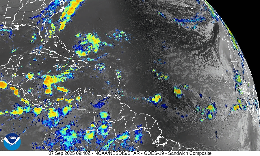
On September 7, the Atlantic remains completely calm with no tropical storms or hurricanes. The National Hurricane Center expects no development over the next 7 days. A weak tropical wave in the central Atlantic is producing scattered showers but shows no signs of organization. Florida and the Gulf of Mexico remain quiet, experiencing only typical late-summer thunderstorms.

**We’re back after a series of technical issues. We apologize for the inconvenience.
TLDR Version: Click Here
Atlantic remains quiet with no tropical development expected in the next week
Atlantic Basin Overview
No Active Storms
The Atlantic basin is completely calm—no tropical depressions, storms, or hurricanes are present. The NHC advises that no tropical cyclone formation is expected over the next seven days.Tropical Waves Noted
A central Atlantic wave near 41°W and 17°N, moving west at 10–15 kt, shows scattered moderate convection—but no sign of imminent development.
Environmental Conditions
Sea Surface Temperatures (SSTs): Still warm across the Gulf and Caribbean (~29–31 °C), but less favorable in the open Atlantic.
Wind Shear: Elevated winds aloft continue across the basin, suppressing convective organization.
Mid-Level Humidity & SAL: Dry air and Saharan dust remain widespread, further limiting storm initiation.
Gulf of Mexico & Caribbean
The Gulf remains quiet and stable, with only typical afternoon sea-breeze thunderstorms occurring along coastal areas. No tropical systems are expected to develop.
Florida & Southeast U.S. Forecast
Florida continues under a late-summer pattern—hot, humid, and featuring scattered afternoon thunderstorms. With no systems nearby and improving sea conditions, no enhanced coastal risks are currently expected.
Rain forecast visualization courtesy of Windy.com

Summary
The Atlantic basin remains quiet, with no active systems or expected development in the short term.
Although tropical waves are present, environmental factors (warm SSTs excluded) are largely unfavorable across the basin.
The Gulf and Florida remain unaffected, experiencing only routine summertime weather.
TL;DR – September 7 Snapshot
No storms in the Atlantic; no development expected for 7 days.
A wave in the central Atlantic shows no signs of imminent organization.
Environmental factors continue to suppress new tropical formation.
Florida and Gulf remain calm with only routine weather patterns.

Atlantic Hurricane Outlook – August 24, 2025: Tropical Storm Fernand forms southeast of Bermuda
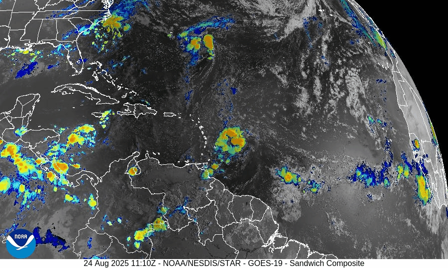
Tropical Storm Fernand has developed in the Atlantic while Erin’s post-tropical remnants continue to generate hazardous surf and rip currents from the Carolinas to New England. Florida and the Gulf of Mexico remain calm, with only daily sea-breeze thunderstorms expected.
TLDR Version: Click Here

Tropical Storm Fernand forms southeast of Bermuda; environmental conditions shaping its strength and lifespan
Atlantic Basin Overview
Tropical Storm Fernand
A new system, Tropical Storm Fernand, has formed approximately 300–400 miles southeast of Bermuda, with sustained winds near 40 mph and moving north-northeastward at about 15 mph. Forecasts support gradual strengthening, possibly into a hurricane by Monday, before weakening as it encounters cooler waters and increasing wind shear. The projected path keeps Fernand well east of Bermuda and away from land. Multiple long-period swells from Fernand, combined with Erin’s lingering effects, sustain hazardous surf and rip current risks along the U.S. East Coast.
Hurricane Erin’s Lingering Hazards
Although Erin has been post-tropical for days, its legacy endures in dangerous surf and life-threatening rip currents from the Carolinas through New England. Earlier in the week, dune breaches, NC‑12 flooding, and evacuations in the Outer Banks were documented. The ocean hazards persist even as the system moves further away.
Invest 99L
A tropical wave in the central Atlantic (Invest 99L) continues to show only limited organization. Environmental conditions—particularly dry mid-level air and moderate wind shear—are hindering its development.
Environmental Conditions
Sea Surface Temperatures (SSTs): SSTs across the Caribbean and Gulf remain warm (29–31 °C / 84–88 °F), which generally fuels storm development. The Main Development Region (MDR) is also running near or slightly above average SSTs, offering environmental support for intensification.
Wind Shear: As of today, Fernand benefits from light wind shear in the immediate area of formation, although models show increasing wind shear after ~36 hours, which should weaken the system. Moderately high shear in the Caribbean and central Atlantic continues to suppress broader basin-wide development.
Mid-level Humidity & Saharan Air Layer (SAL): While overall moisture in the western tropical Atlantic remains sufficient, pockets of dry mid-level air—partly due to lingering SAL intrusions—are inhibiting storm convection and formation in some areas, including near Invest 99L.
Gulf of America (Mexico) & Caribbean
The Gulf of America (Mexico) remains quiet, with high pressure dominating. Standard afternoon sea-breeze thunderstorms continue along the coast, but no organized tropical development is expected in the near term. SSTs remain very warm (29–31 °C), making the region climatically conducive to storm formation later in the season.
Florida & Southeast U.S. Forecast
Across the Florida Peninsula, it's the usual late-August pattern: hot and humid, with daily sea-breeze thunderstorms. Afternoon rainfall, frequent lightning, and gusty winds persist. No tropical threats are present at this time.
Along the Atlantic coast from Florida to New England, rip current risk remains elevated due to swells generated by both Erin and Fernand. Hazards are expected to continue into early next week—beachgoers should remain cautious and heed local advisories.
Rain forecast visualization courtesy of Windy.com
Summary
Fernand has formed southeast of Bermuda and is expected to strengthen briefly while remaining over open water; weakening is likely within a few days.
Erin’s remnants continue to produce dangerous coastal surf and rip currents, particularly from the Carolinas northward.
Invest 99L shows low development potential due to hostile environmental conditions, including dry air and moderate shear.
Gulf and Florida remain storm-free, with only routine summertime convection.
TL;DR – August 24 Snapshot
Fernand forms and may briefly become a hurricane, but stays out at sea.
Hazardous surf and rip currents continue along the U.S. East Coast from Erin’s legacy.
Development of Invest 99L is stunted by dry air and moderate shear.
Gulf of Mexico and Florida remain calm, with season-typical afternoon storms only.