Atlantic Hurricane Outlook – September 17, 2025
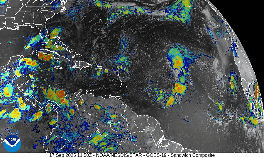
On September 17, Tropical Depression Seven formed in the central Atlantic and is expected to strengthen into Tropical Storm Gabrielle within 24 hours. A separate wave near the Cabo Verde Islands shows little immediate development potential due to dry air and Saharan dust. Warm waters and easing wind shear support further organization of the depression. Florida and the Gulf of America remain calm, with only typical late-summer heat, humidity, and scattered storms.

Tropical Depression Seven has formed; slow strengthening expected; Atlantic otherwise quiet
Atlantic Basin Overview
Tropical Depression Seven (formerly Invest 92L)
A new tropical system, now Tropical Depression Seven, has formed in the central tropical Atlantic. It is currently located near 13.7°N, 45.9°W, moving west at about 13 mph, with maximum sustained winds of 35 mph and a central pressure of around 1007 mb. It could strengthen into Tropical Storm Gabrielle by Wednesday afternoon or evening, according to the National Hurricane Center.Tropical Wave East-Southeast of the Cabo Verde Islands
There is also a tropical wave producing disorganized showers and thunderstorms east-southeast of the Cabo Verde Islands. Environmental conditions are only marginally favorable, so any development is expected to be slow as it moves westward at 15-20 mph.
Environmental Conditions
Sea Surface Temperatures (SSTs): Warm enough in the tropical Atlantic to support further strengthening of the depression.
Wind Shear: Moderate shear currently limiting rapid intensification, but shear is forecast to ease somewhat in the path of Tropical Depression Seven.
Dry Air & Saharan Air Layer (SAL): Dry mid-level air and dust from the Saharan Air Layer remain present over portions of the eastern Atlantic. These are expected to affect the wave near Cabo Verde more than the depression.
Gulf of America (Mexico) & Caribbean
The Gulf and Caribbean remain quiet, with no tropical disturbances showing signs of organization. Weather in these areas continues to be typical for mid-September: heat, humidity, and scattered thunderstorms.
Florida & Southeast U.S. Forecast
Florida continues under its usual early-fall pattern: hot, humid, with afternoon thunderstorms. As of now, no tropical threat to Florida is indicated from Tropical Depression Seven or the eastern Atlantic wave. Coastal conditions are stable.
Rain forecast visualization courtesy of Windy.com

Summary
Tropical Depression Seven is now active and likely to become Tropical Storm Gabrielle soon.
The wave near Cabo Verde is being watched but development will be slow and is less likely in the near term.
Environmental conditions are mixed: SSTs favorable; shear and dry air remain suppressing factors.
Gulf, Caribbean, Florida remain calm with routine summer weather and no tropical risks at this moment.
TL;DR – September 17 Snapshot
Tropical Depression Seven has formed and may become Gabrielle by Wednesday.
Another weak tropical wave is being monitored but poses no imminent threat.
Dry air, SAL, and shear are still important suppressors.
Florida / Gulf of Mexico remain clear of tropical risk for now.