
Atlantic Hurricane Outlook – September 3, 2025
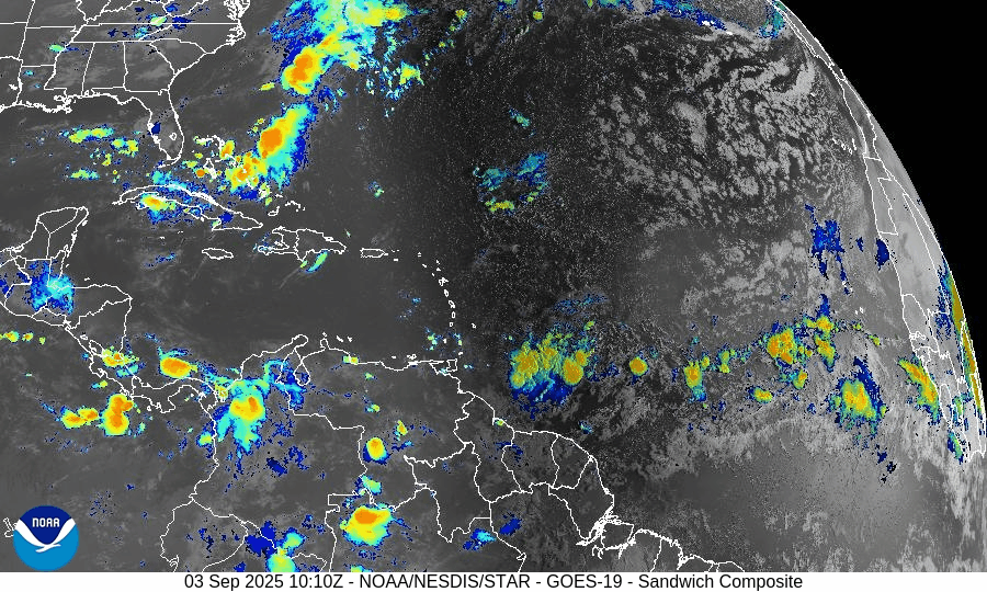
On September 3, the Atlantic basin remains free of active tropical cyclones. A tropical wave emerging from Africa is showing increased signs of organization, with the NHC assigning a 70% chance of development over the next week. This system could become Tropical Depression Seven or Tropical Storm Gabrielle. Florida and the Gulf of Mexico remain quiet, experiencing only typical late-summer thunderstorms.

TLDR Version: Click Here
Atlantic remains quiet; African wave now has 70% 7-day development odds
Atlantic Basin Overview
No Active Storms
The Atlantic basin continues to be free of active tropical cyclones—no storms are currently present.Tropical Wave Off Africa
A tropical wave exiting Africa is gaining strength. The NHC now gives this system a 0% development chance in 48 hours, rising to 70% over 7 days. Development into Tropical Depression Seven—and possibly Tropical Storm Gabrielle—is considered likely by the weekend.
Environmental Conditions
Sea Surface Temperatures (SSTs): Remain warm in the Caribbean and Gulf (about 29–31 °C) but cooler farther east, where the African wave is located.
Wind Shear: Moderate to strong shear persists across much of the Atlantic but may ease near the developing wave.
Mid-Level Humidity & SAL: Dry air and the Saharan Air Layer (SAL) are widespread, but are expected to diminish along the wave’s path as it tracks westward.
Gulf of America (Mexico) & Caribbean
The Gulf remains quiet, dominated by high pressure. Only routine afternoon thunderstorms are expected along coastal areas; no tropical development is expected at this time.
Florida & Southeast U.S. Forecast
Florida continues with typical early-September weather: hot and humid, with scattered sea-breeze-driven afternoon thunderstorms. No tropical threats are expected. Coastal waters are calmer as the Atlantic’s longtime surf persists from prior systems but gently subsides.
Rain forecast visualization courtesy of Windy.com

Summary
Atlantic basin remains calm with no systems currently active.
A tropical wave off Africa shows a high (70%) chance of developing into a tropical cyclone within 7 days.
Environmental factors—warm SSTs but competing dry air, SAL, and wind shear—will determine if and when development occurs.
Gulf and Florida remain storm-free and continue typical late-summer weather patterns.
TL;DR – September 3 Snapshot
Atlantic is quiet with no storms.
African wave now has 70% development odds over the next 7 days.
Atlantic environment remains marginal but improving near the wave.
Florida and Gulf remain calm with routine storms.

Atlantic Hurricane Outlook – August 26, 2025
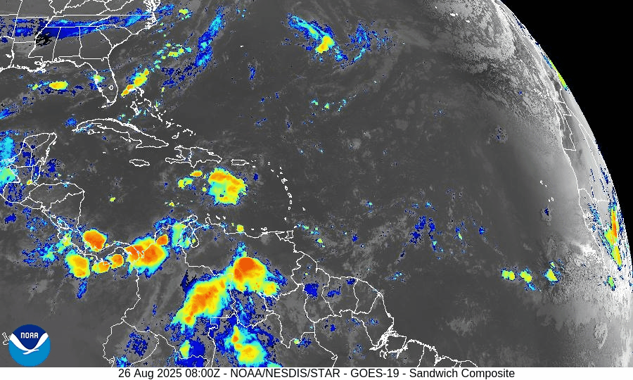
On August 26, Tropical Storm Fernand weakened over cooler waters east-northeast of Bermuda and is expected to become post-tropical by Wednesday. While Fernand poses no threat to land, Erin’s swells are still driving dangerous rip currents along the U.S. East Coast. Florida and the Gulf of Mexico remain quiet, experiencing only typical late-August thunderstorms.
TLDR Version: Click Here
Tropical Storm Fernand weakens offshore; Erin’s surf legacy lingers while tropics turn quiet
Atlantic Basin Overview
Tropical Storm Fernand

As of Tuesday morning, Fernand is located about 635 miles east-northeast of Bermuda, moving northeast at ~14 mph with maximum sustained winds near 45 mph and a central pressure of 1005 mb. The storm has weakened over cooler waters and moderate shear, and is forecast to transition into a post-tropical system by Wednesday, dissipating altogether by Thursday. No watches or warnings are in effect, and Fernand poses no threat to land.
Hurricane Erin’s Legacy
Though Erin has been gone for days, its immense size and powerful wave field continue to leave a footprint along the East Coast. Long-period swells and dangerous rip currents remain a hazard from the Carolinas through New England, particularly in areas with open exposure to the Atlantic.
Other Atlantic Activity
The National Hurricane Center reports no active disturbances of concern. A tropical wave that had entered the Caribbean has been choked off by dry air and shear, with 0–10% development odds over the next week
Environmental Conditions
Sea Surface Temperatures (SSTs): The Caribbean and Gulf remain very warm (29–31 °C), supportive of storm formation. In the North Atlantic, Fernand is moving into cooler waters, which will force weakening.
Wind Shear: Shear is moderate over Fernand and forecast to increase, hastening its post-tropical transition. Stronger shear persists across much of the MDR, suppressing new development.
Mid-Level Relative Humidity: Dry mid-level air continues across the central Atlantic, limiting convective organization for any tropical waves.
Saharan Air Layer (SAL): Dust-laden air spans the eastern and central Atlantic, further capping deep convection and hindering tropical development.
Gulf of Mexico & Caribbean
The Gulf remains quiet under high pressure, with no signs of organized development. Only routine afternoon thunderstorms are occurring along coastal regions. Despite very warm waters, the Gulf shows no near-term tropical threats.
Florida & Southeast U.S. Forecast
Florida is under a typical late-August pattern: hot, humid conditions with scattered afternoon thunderstorms driven by sea breezes. Some morning showers are possible along the Gulf Coast.
Along the Atlantic beaches, hazardous surf and rip currents remain the main concern, with energy still propagating from Erin’s remnants and Fernand’s offshore circulation
Rain forecast visualization courtesy of Windy.com

Summary
Fernand has weakened to a 45 mph storm and will become post-tropical by Wednesday.
Erin’s legacy continues to affect the East Coast with dangerous surf and rip currents.
No new Atlantic systems show signs of development; odds remain very low.
Gulf of Mexico and Florida are quiet, with only routine late-summer storms.
Environmental conditions: Warm SSTs but hostile shear, dry air, and SAL are suppressing new activity.
TL;DR – August 26 Snapshot
Fernand weakens offshore; no land impacts expected.
Erin’s swells continue to fuel rip currents along the East Coast.
SAL, dry air, and wind shear are limiting new storm development.
Gulf and Florida remain quiet aside from typical thunderstorms.