
Atlantic Hurricane Outlook – August 27, 2025
On August 27, Tropical Storm Fernand transitioned into a post-tropical system southeast of Newfoundland. While Fernand poses no threat to land, Erin’s long-period swells continue to drive dangerous surf and rip currents from the Carolinas through New England. Florida and the Gulf of Mexico remain calm, with only typical late-August thunderstorms and no signs of tropical development.
TLDR Version: Click Here
Tropical Storm Fernand becomes post-tropical over open waters; East Coast surf threats persist
Atlantic Basin Overview

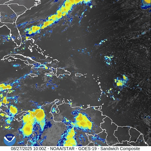
Tropical Storm Fernand
As of 5 AM AST (0900 UTC), Fernand is situated near 38.3° N, 50.8° W, approximately 590 miles southeast of Cape Race, Newfoundland. The system carries sustained winds of 45 mph, is moving east at 12 mph, and maintains a central pressure of 1007 mb.
No coastal watches or warnings are active. Fernand is expected to transition into a post‑tropical system later today, then evolve into a trough and dissipate by Thursday.
Hurricane Erin’s Lingering Surf Impacts
Despite being long gone, Erin's energy continues to affect coastal waters. East Coast beaches—from the Carolinas through New England—continue to experience rough surf and dangerous rip currents.
No Other Tropical Activity
There are no new tropical disturbances of concern at this time, and forecast models show an inactive Atlantic basin in the short term.
Environmental Conditions
Sea Surface Temperatures (SSTs): Waters remain warm in the subtropics but are cooling northward—supporting Fernand's decay.
Wind Shear: Moderate winds aloft are increasing and will help dissipate Fernand.
Mid-Level Humidity & SAL: Dry air and dust from the Saharan Air Layer still suppress convection across the Atlantic, limiting new storm formation.
Gulf of Mexico & Caribbean
The Gulf remains quiet and stable, dominated by high pressure. Afternoon thunderstorms continue in coastal areas, but no tropical development is expected.
Florida & Southeast U.S. Forecast
Typical late-August weather prevails: hot and humid with scattered afternoon storms across Florida.
Beaches along the Atlantic continue to face elevated rip current risks, driven by the lingering swell from Erin and residual energy from Fernand.
Rain forecast visualization courtesy of Windy.com
Summary

Fernand weakens as it becomes post-tropical; no land threat.
Erin’s surf legacy continues to endanger East Coast recreation.
Atlantic basin remains quiet—no new systems.
Gulf and Florida are calm aside from routine summer storms.
Hostile environmental conditions (cooler SSTs, shear, dry air, SAL) limit development.
TL;DR – August 27 Snapshot
Fernand becomes post-tropical in the open ocean—no land threat.
Rip currents and rough surf continue to challenge East Coast beaches.
Active development unlikely; Atlantic remains quiet.
Florida and Gulf of Mexico see only typical summer storms.
Atlantic Hurricane Outlook – August 16, 2025: Erin intensifies over the central Atlantic
Hurricane Erin has intensified over the central Atlantic while a weak Gulf disturbance delivers rain to South Texas and NE Mexico. Florida sees typical summer storms, with rising rip-current risks along Atlantic beaches as Erin’s swells arrive.
TLDR Version; Click Here

Erin intensifies over the central Atlantic; weak Gulf disturbance keeps rain focused on far South Texas and NE Mexico; U.S. impacts mainly marine
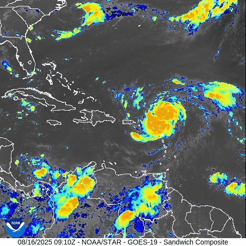
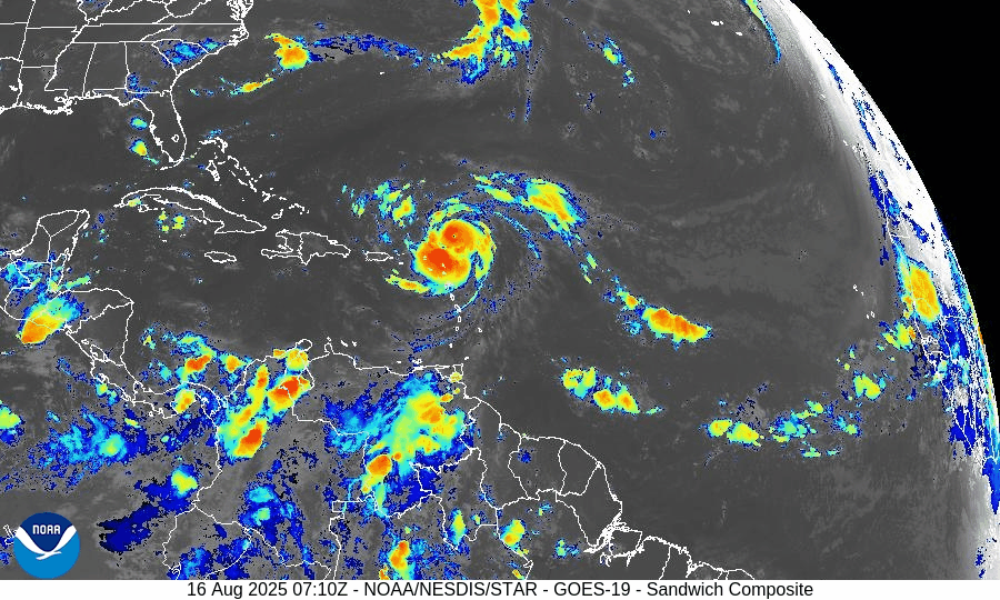
Hurricane Erin has strengthened over the central tropical Atlantic and remains on a track that keeps it well offshore of the U.S. mainland. In the Gulf of Mexico, a weak, broad low near the Bay of Campeche continues to funnel tropical moisture into far South Texas and northeastern Mexico, with low odds of tropical development. For most U.S. coastlines, the primary near-term impacts are building surf and an elevated rip-current risk as Erin’s long-period swells arrive.
Atlantic Basin Overview
Hurricane Erin (central Atlantic): Erin has intensified into a major hurricane over very warm waters with supportive upper-level ventilation. Forecast guidance continues to favor a gradual bend to the northwest and then north this weekend into early next week, keeping the core well away from the Bahamas and U.S. East Coast. Even with an offshore track, long-period swells will propagate toward the Western Atlantic shorelines, bringing hazardous surf and rip currents ahead of any weather changes locally.
Elsewhere in the basin: A typical mid-August “wave train” extends from Africa across the Main Development Region (MDR). Most waves are battling pockets of dry air/Saharan dust and intermittent mid- to upper-level shear, limiting organization in the short term.


Gulf of America (Mexico) & Caribbean
Southwest Gulf disturbance (Bay of Campeche): A broad trough/weak low continues to drift west-northwest toward northeastern Mexico. Organization is limited; development odds remain low. Regardless of development, expect periods of heavy rain, locally gusty squalls, and choppy seas from the lower Texas coast southward into Tamaulipas/Veracruz.
Rest of the Gulf: Typical summer regime with scattered sea-breeze thunderstorms near the margins; light to moderate onshore flow most areas, with evening pulses of fresh easterlies along the Yucatán coast.
Caribbean Sea: Fresh trades continue in the south-central Caribbean with passing showers; no organized tropical systems at this time.
Florida & Southeast U.S. Outlook
Florida (statewide): A classic August pattern—hot, humid, and scattered to numerous afternoon thunderstorms driven by sea-breeze collisions and outflow boundaries. Storms are not tropical in origin but can produce frequent lightning, brief torrential rain, and localized gusty winds.
Atlantic beaches (FL/GA/SC/NC): Expect a rising rip-current risk and building surf through the weekend into early next week as Erin’s swells arrive. Check local beach forecasts and heed lifeguard guidance.
Gulf beaches (FL Panhandle/West FL): Typical late-day storms; rip-current risk mainly tied to local winds and storm outflows rather than distant swell.
Rain forecast visualization courtesy of Windy.com
Environmental Setup (Why/Why Not Development)
Sea Surface Temperatures: MDR, Caribbean, and Gulf waters are well above seasonal averages, supplying ample oceanic heat content (fuel) for systems that find a favorable atmospheric window.
Wind Shear: Shear is comparatively lower along Erin’s corridor (supporting its intensification) but patchy and occasionally moderate to high elsewhere—enough to disrupt other waves.
Moisture & SAL: Mid-level moisture is increasing west of ~45–50°W, but Saharan Air Layer intrusions still clip portions of the eastern/central MDR, injecting dry air and capping convection for several waves.
Preparedness Note

Even when a hurricane stays far offshore, its swells can be dangerous. If you’re heading to the beach, swim near lifeguards, avoid jetties/inlets during high surf, and review local rip-current statements. For Gulf communities under heavy rain today, avoid flooded roadways and allow extra travel time.
TL;DR – August 16 Snapshot
Erin is a major hurricane over the central Atlantic; expected to turn north and remain offshore of the U.S.
Bay of Campeche disturbance: Low development odds; brings heavy rain to far South Texas and NE Mexico.
Florida & Southeast: Typical hot, stormy afternoons; rip-current risk rising on Atlantic beaches from Erin’s distant swells.
Overall Atlantic remains active with waves, but shear and dry air are limiting most systems—for now.