
Atlantic Hurricane Outlook – August 17, 2025: Erin Got Big
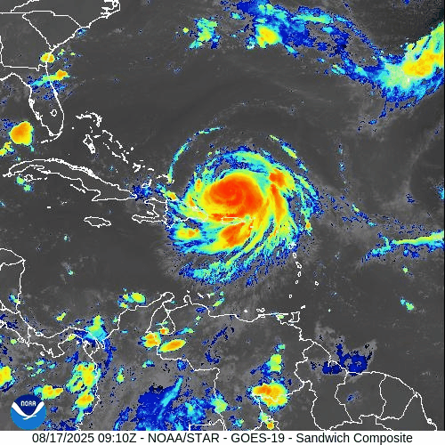
Hurricane Erin briefly reached Category 5 strength but has since weakened to a Category 4 in the Atlantic. While multiple tropical waves remain active, dry air and wind shear are keeping them disorganized. The Gulf of Mexico sees lingering rain, and Florida continues with typical summer storms.
TLDR Version; Click Here
Current Status: Active major hurricane in the Atlantic
Hurricane Erin (Category 3, formerly Cat 5 then 4)
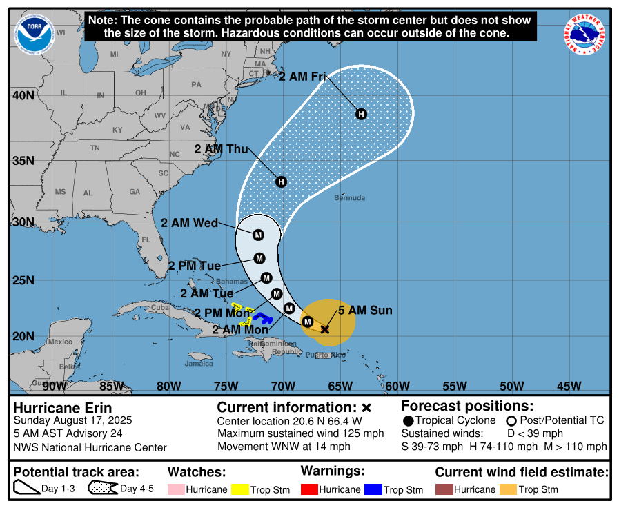
As of this morning, Hurricane Erin is holding as a Category 3 hurricane with maximum sustained winds near 125mph, after briefly reaching Category 5 intensity yesterday with peak winds of 160 mph.
Erin underwent rapid intensification in the open Atlantic but has since begun a gradual weakening trend due to slight increases in wind shear and internal structural changes (eyewall replacement cycle).
The storm remains over open water and poses no immediate land threat, but it continues to serve as a reminder of how quickly systems can ramp up when environmental conditions align.


Central & Eastern Atlantic
Multiple tropical waves continue to traverse the Main Development Region (MDR).
A wave near 35–40°W remains disorganized with only scattered convection.
Another wave just off Africa near 20–25°W is embedded in the monsoon trough, but Saharan Air Layer (SAL) dust and dry air should keep development limited in the short term.
Gulf of Mexico
Broad moisture and unsettled weather persists across the central and western Gulf.
No organized tropical system is expected, but localized heavy rain and thunderstorms may impact coastal Texas and Louisiana.
Upper-level conditions are not conducive for development at this time.
Florida & Southeast U.S.
Typical afternoon thunderstorms continue across the Florida peninsula, fueled by Gulf moisture and sea-breeze interactions.
No tropical threats are expected for the state today.
Rain forecast visualization courtesy of Windy.com
Key Environmental Factors
Sea Surface Temperatures (SSTs): 29–31 °C across the Gulf and Caribbean, with the MDR slightly above average — plenty of available fuel.
Wind Shear: Increasing in the western Atlantic, contributing to Erin’s weakening and suppressing MDR organization.
Moisture: Pockets of dry air and Saharan dust continue to limit development in the eastern Atlantic.
TL;DR

Hurricane Erin: Now a Category 3, after peaking at Cat 5 yesterday; remains over open Atlantic, no land threat.
Atlantic Tropics: Several waves, but limited organization due to dry air and shear.
Gulf of Mexico: Moisture lingers, rain possible, but no tropical development.
Florida: Routine summer storms, no tropical system expected.
CAT5Prep.com is staying on top of the storms. While Hurricane Erin may have passed the point of direct threat for many, there is more movement in the MDR (Main Development Region) of the Atlantic, and we all need to stay on our toes. The MDR is a critical area for tropical cyclone formation, and activity there often sets the tone for the rest of the hurricane season.
Atlantic Hurricane Outlook – August 4, 2025: Tropical Storm Dexter Forms; Two Other Systems Under Watch
Tropical Storm Dexter forms off the East Coast with no land threat. Meanwhile, a tropical wave off Africa and a low near the Southeast U.S. are being monitored as conditions slowly shift toward a more active period.
*Those who like data, continue reading. Those it prefer the quick version, jump to the TL;DR here.
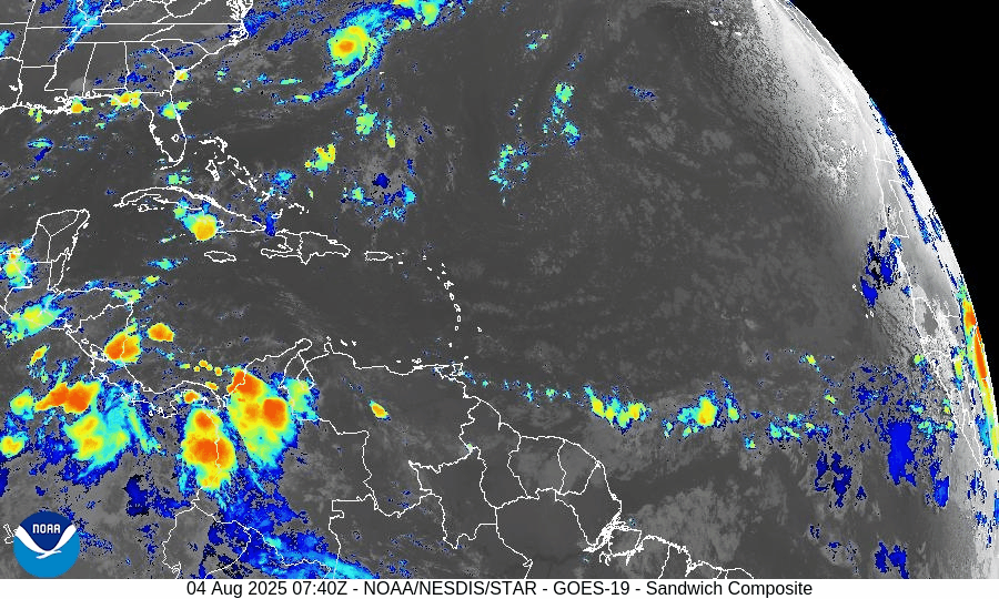
Tropical Storm Dexter has developed in the western Atlantic, while two additional systems are being monitored for potential development. Conditions across the basin remain dynamic—with storm formation possible in coming days.
Atlantic Basin Summary
Tropical Storm Dexter: The fourth named storm of the 2025 season formed late Sunday night, now located ~255 miles northwest of Bermuda. Maximum sustained winds are 45 mph, and the system is moving east-northeast. It’s expected to remain over open water and become post-tropical by Wednesday with no threat to U.S. land.
Disturbance AL95: A non-tropical low pressure area off the Southeast U.S. coast is being monitored with medium (30%) development chance over 7 days. Movement is east-northeast under weak shear, and formation may remain offshore.
New tropical wave emerging off Africa (~30°W): Forecast to track westward with scattered convection. The formation chance is 50% over 7 days, indicating growing potential for a tropical depression if favorable conditions develop.
Environmental Conditions
Sea Surface Temperatures (SSTs):
Waters in the Gulf of Mexico, Caribbean, and MDR remain warm at 29–31°C (84–88°F)—providing ample energy if atmospheric conditions become supportive.Wind Shear:
Still moderate to high across much of the Atlantic, limiting vertical storm structure. However, shear may relax in the western basin later this month.Saharan Air Layer (SAL):
Persistent dry, dusty air continues to suppress convection, especially over the eastern and central Atlantic. This remains a major inhibiting factor for newly emerging systems.Moisture:
Improving moisture levels seen in the western Caribbean and Gulf, though much of the basin remains too dry for sustained disturbance development.
Gulf of America (Mexico) & Caribbean Region
No tropical systems currently forming.
A dominant high-pressure ridge promotes generally calm, hot conditions across the Gulf and Caribbean.
Scattered showers remain typical for August, with no organized convection tied to tropical disturbances.
GOES-19 - Sector view: Gulf
GOES-19 - Sector view: Caribbean
Florida Forecast
Highs: Upper 80s to near 90°F under humid conditions.
Afternoon thunderstorms: 40–50% chance, typically from sea breeze convergence—non-tropical in origin.
Winds: Light and variable inland; southeasterly near the coast.
No tropical storm impacts are expected today.
Rain forecast visualization courtesy of Windy.com
Prep Tip of the Day
Stay connected to emerging tropical watches and alerts: sign up for NOAA and county-level emergency notifications, test weather radios, and review your communication plans with family or household members.
Looking Ahead
Though Dexter poses no immediate risk to land, the emerging wave and mid-Atlantic trough (AL95) warrant attention. The signal is clear: early August may mark the beginning of a more active period in the tropical Atlantic.
TL;DR – August 4, 2025 Summary
Tropical Storm Dexter forms off the East Coast—staying far offshore and weakest by midweek.
Low pressure (AL95) offshore Southeast U.S. with 30% development chance.
New wave off Africa (~30°W) entering the Atlantic—50% chance of development in 7 days.
SSTs supportive but SAL and shear remain inhibitory.
No threat to Florida; typical summer thunderstorms expected.