
Atlantic Hurricane Outlook – August 27, 2025
On August 27, Tropical Storm Fernand transitioned into a post-tropical system southeast of Newfoundland. While Fernand poses no threat to land, Erin’s long-period swells continue to drive dangerous surf and rip currents from the Carolinas through New England. Florida and the Gulf of Mexico remain calm, with only typical late-August thunderstorms and no signs of tropical development.
TLDR Version: Click Here
Tropical Storm Fernand becomes post-tropical over open waters; East Coast surf threats persist
Atlantic Basin Overview

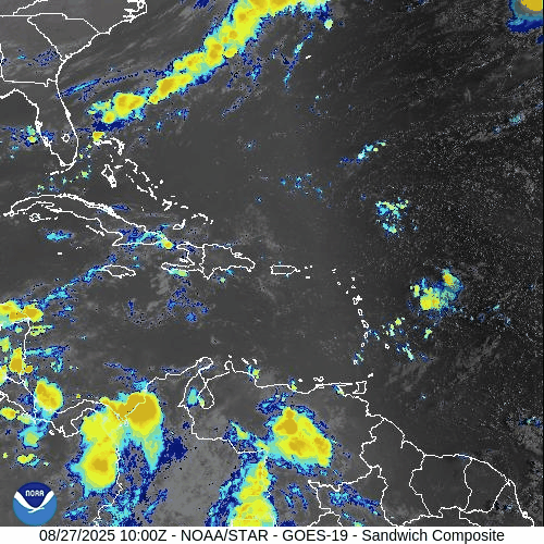
Tropical Storm Fernand
As of 5 AM AST (0900 UTC), Fernand is situated near 38.3° N, 50.8° W, approximately 590 miles southeast of Cape Race, Newfoundland. The system carries sustained winds of 45 mph, is moving east at 12 mph, and maintains a central pressure of 1007 mb.
No coastal watches or warnings are active. Fernand is expected to transition into a post‑tropical system later today, then evolve into a trough and dissipate by Thursday.
Hurricane Erin’s Lingering Surf Impacts
Despite being long gone, Erin's energy continues to affect coastal waters. East Coast beaches—from the Carolinas through New England—continue to experience rough surf and dangerous rip currents.
No Other Tropical Activity
There are no new tropical disturbances of concern at this time, and forecast models show an inactive Atlantic basin in the short term.
Environmental Conditions
Sea Surface Temperatures (SSTs): Waters remain warm in the subtropics but are cooling northward—supporting Fernand's decay.
Wind Shear: Moderate winds aloft are increasing and will help dissipate Fernand.
Mid-Level Humidity & SAL: Dry air and dust from the Saharan Air Layer still suppress convection across the Atlantic, limiting new storm formation.
Gulf of Mexico & Caribbean
The Gulf remains quiet and stable, dominated by high pressure. Afternoon thunderstorms continue in coastal areas, but no tropical development is expected.
Florida & Southeast U.S. Forecast
Typical late-August weather prevails: hot and humid with scattered afternoon storms across Florida.
Beaches along the Atlantic continue to face elevated rip current risks, driven by the lingering swell from Erin and residual energy from Fernand.
Rain forecast visualization courtesy of Windy.com
Summary

Fernand weakens as it becomes post-tropical; no land threat.
Erin’s surf legacy continues to endanger East Coast recreation.
Atlantic basin remains quiet—no new systems.
Gulf and Florida are calm aside from routine summer storms.
Hostile environmental conditions (cooler SSTs, shear, dry air, SAL) limit development.
TL;DR – August 27 Snapshot
Fernand becomes post-tropical in the open ocean—no land threat.
Rip currents and rough surf continue to challenge East Coast beaches.
Active development unlikely; Atlantic remains quiet.
Florida and Gulf of Mexico see only typical summer storms.