

Atlantic Hurricane Outlook – August 12, 2025: Tropical Storm Erin Strengthens; Gulf & Florida Remain Calm
Tropical Storm Erin strengthens in the eastern Atlantic with hurricane potential, while the Gulf of Mexico and Florida remain calm. Here’s today’s August 12, 2025 hurricane update.
TLDR Version; Click Here
Tropical Storm Erin, the fifth named storm of the 2025 season, has formed and is steadily intensifying in the eastern Atlantic. No tropical systems are currently threatening U.S. coastlines, but the atmosphere is becoming more favorable for additional activity later in the week.
Atlantic Basin Summary
Tropical Storm Erin is centered roughly 560 miles west-northwest of the Cabo Verde Islands, moving west at 22 mph with sustained winds near 45 mph. Models suggest Erin could strengthen into a hurricane within the next few days and potentially become the season’s first major hurricane. Forecasters anticipate a gradual curve to the northwest later in the week, keeping land impacts unlikely for now.
While Erin organizes, no other significant systems are expected to develop across the Atlantic this week, though other waves are being monitored as conditions continue to evolve.
GEPS Track Model for TS Erin August 12, 2025
GEFS Track Model for TS Erin August 12, 2025
Gulf of America (Mexico) & Caribbean Conditions
Gulf of America (Mexico): Stable weather with no tropical threats. Sea surface temperatures remain elevated—around 2°F above average in early August —but without supportive atmospheric dynamics for development.
Caribbean Sea: General trade wind flow continues, with only typical convective activity. No organized disturbances are present.
GOES - GULF Sandwich August 12, 2025
GOES - Caribbean Sandwich August 12, 2025
Florida Outlook
Forecast for Today: Expect typical mid-August weather—hot, humid, and afternoons marked with scattered sea-breeze thunderstorms that are inland-driven, not tropical. No storm threats are forecasted for the Sunshine State today.
Rain forecast visualization courtesy of Windy.com
Outlook Summary & Preparation
Erin is likely to become a hurricane, but initial tracks keep it far from U.S. landmasses.
Conditions across other tropical basins are quiet but trending toward increased activity as the season progresses.
Watch and prepare calm: Summer heat and moisture supply are ample—ensuring your supplies and plans are ready strengthens resilience.
TL;DR – August 12 Snapshot
Tropical Storm Erin forming and intensifying; likely to become hurricane/maybe a major one.
No U.S. impacts expected in the near term.
Gulf and Florida calm—just routine summer storms.
Season building toward higher activity later this week.
Stay vigilant and stay updated with Cat5Prep.
Atlantic Hurricane Outlook – August 8, 2025: Dexter Is Now Post-Tropical; Invest 96L Gains Strength
Post-Tropical Cyclone Dexter exits the Atlantic, while Invest 96L shows increasing potential for tropical development. Conditions remain favorable with record-warm waters and weakening Saharan dust.
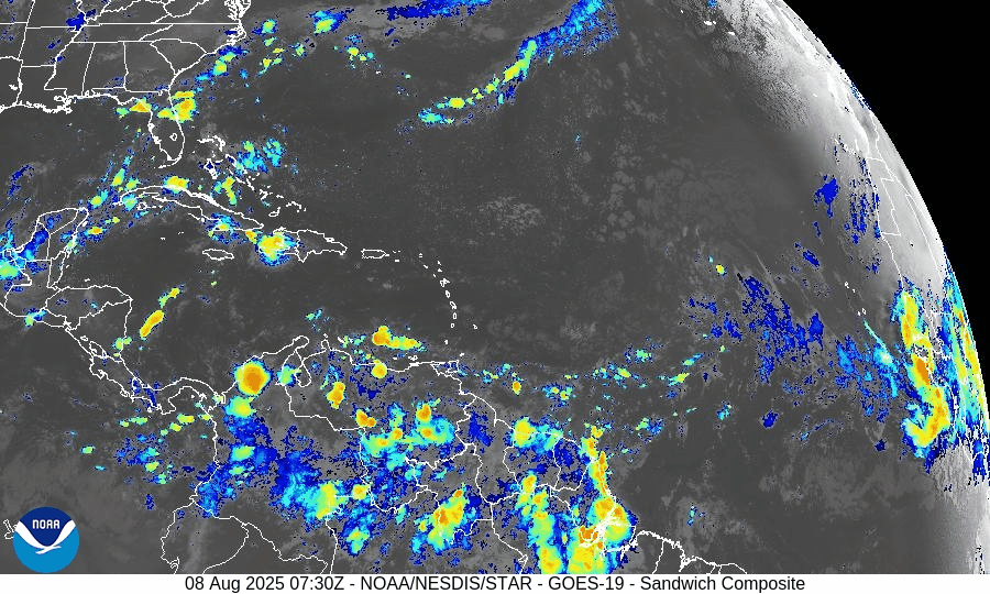
Post-Tropical Cyclone Dexter is moving off into the North Atlantic, fully transitioning into an extratropical system. Meanwhile, tropical wave Invest 96L in the central Atlantic now has a high chance of development, and another system further east offers mid-range development potential.
Atlantic Basin Overview
Dexter has become an expanded, post-tropical storm centered near 41.4° N, 50.4° W
—convection is waning and structure is elongated. (NHC advisory)Invest 96L (tropical wave near ~38° W):
Development chances now stand at 60% within 7 days. Recent observations show disorganized showers, but environmental trends suggest improved potential.New wave along ~38° W with an embedded 1011 mb low around 17° N:
Minimal convection currently, but models indicate conditions may become more favorable later this weekend.
—Chance of development: Low in 48 hours, medium in 7 days.
Environmental Conditions
Sea Surface Temperatures (SSTs): Remain strongly elevated—2–4 °F above average, with localized hotspots reaching 90 °F—offering ample fuel for future storm growth.
Wind Shear: Still moderate to high in the central tropical Atlantic; however, models suggest gradual easing may occur later in the month.
Saharan Air Layer (SAL): Though dust continues to suppress early-season convection, its influence is weakening, particularly in the western basin.
Dust & SAL data from Windy.com
Gulf & Caribbean Update
No tropical activity present.
A high-pressure ridge maintains calm, dry conditions across both regions, with only typical late-summer showers in coastal zones.
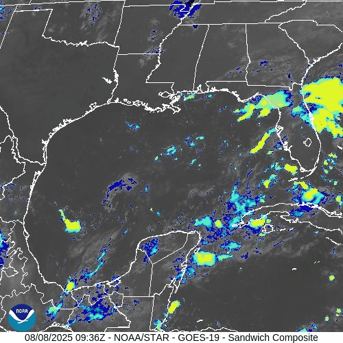
GOES-19 - Sector view: Gulf of America
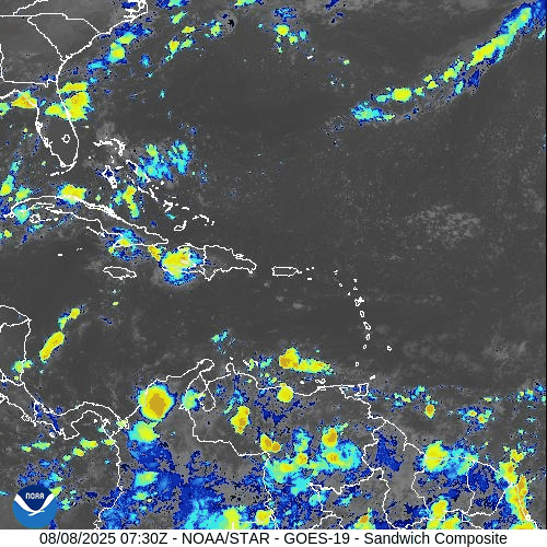
GOES-19 - Sector view: Caribbean
Florida Forecast
Highs: Near 90 °F, with sticky, humid air.
Rain: 40–50% chance of afternoon thunderstorms driven by sea breezes.
Winds: Light and variable; no tropical weather expected.
Rain forecast visualization courtesy of Windy.com
Prep Tip of the Day
With Invest 96L showing increasing organization potential, now is an excellent time to check:
Hurricane supply kits
Evacuation plans
Emergency alert systems across your household
TL;DR – August 8 Snapshot
Dexter has become post-tropical—no land threat.
Invest 96L: 60% chance of development over the next week.
Another eastern wave: Low immediate risk, medium chance in 7 days.
SSTs warm, SAL draining, shear easing—conditions veering toward more activity.
Stay tuned—peak season is ramping up quickly.
For daily updates, stay locked to Cat5Prep.com.