Atlantic Hurricane Outlook – October 1, 2025
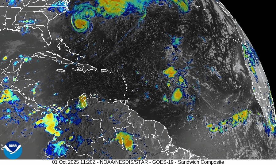
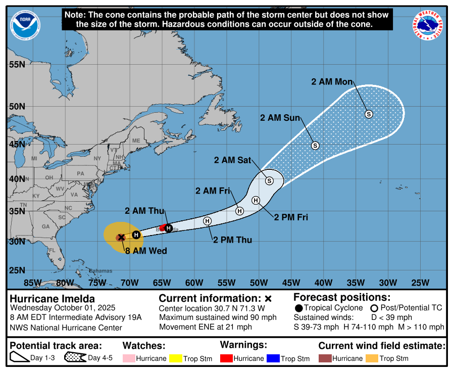
On October 1, Hurricane Imelda has strengthened to 90 mph as it accelerates toward Bermuda, where a hurricane warning is in effect. The storm is forecast to bring damaging winds, heavy rain, and coastal flooding to the island tonight. Meanwhile, Humberto remains offshore, producing hazardous surf and rip currents across the Atlantic. Environmental conditions—warmer SSTs but rising shear and Saharan dust—support Imelda’s current strength but will limit its future intensification. Florida and the Gulf of America remain calm.

Imelda attains hurricane strength en route to Bermuda; Humberto adds to oceanic hazards
Atlantic Basin Overview
Hurricane Imelda
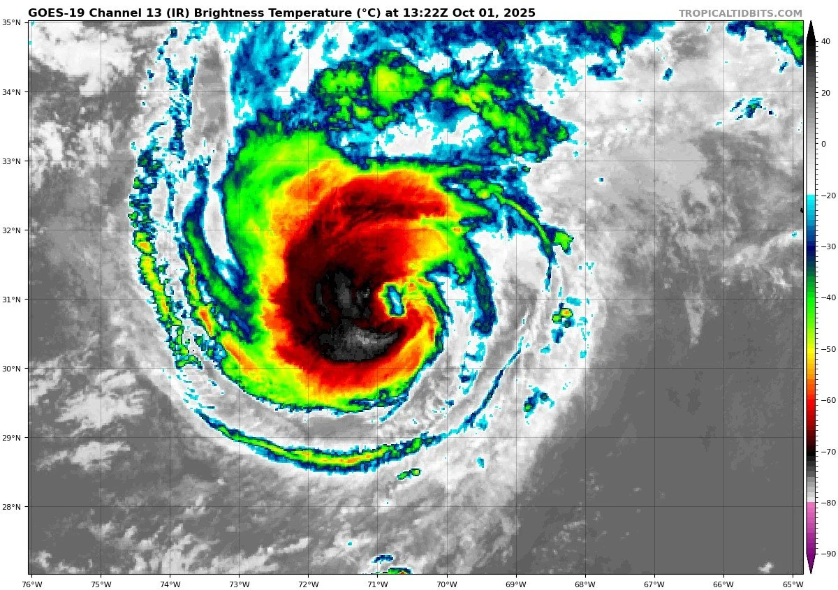
As of 8:00 AM EDT, Imelda is located near 30.7°N, 71.3°W, about 395 miles west-southwest of Bermuda. It’s moving east-northeast at 21 mph with maximum sustained winds around 90 mph and a central pressure near 974 mb. A hurricane warning remains in effect for Bermuda. Imelda’s core is expected to pass near or over Bermuda tonight before heading away.Hurricane Humberto & Other Disturbances
Humberto remains active farther east in the Atlantic, contributing to dangerous marine conditions (swells, rip currents) that extend toward the U.S. East Coast. No new significant tropical developments are imminent per the latest outlooks.
Hurricane Imelda


Environmental Conditions
Sea Surface Temperatures (SSTs):
SSTs along Imelda’s projected track remain warm enough to support hurricane intensity as it approaches Bermuda, though cooler waters ahead will begin to weaken it over time.Wind Shear:
Moderate to increasing shear is expected, especially as Imelda accelerates east-northeast. This shear will work against further intensification and eventually strip its convection.Humidity & Dry Air / Saharan Air Layer (SAL):
Dry mid-level air and dust intrusions from the Saharan Air Layer continue to challenge Imelda’s outer circulation. These environmental suppressors reduce convective vigor, particularly in its outer bands. The combined influence of shear and dry air will limit how strong Imelda can become.
Gulf of America & Caribbean
The Gulf of America and Caribbean remain quiet with no organized tropical systems. Only typical late-summer convection (showers and thunderstorms) is present.
Florida & Eastern U.S. Forecast
Florida and the U.S. Eastern Seaboard are not expected to see a direct landfall from Imelda, as the storm is turning away. However, outer bands may brush parts of the Southeast with gusty showers and elevated surf. Dangerous surf and rip current conditions will continue along the Atlantic coastline as Imelda and Humberto generate swells offshore.
Rain forecast visualization courtesy of Windy.com

TL;DR – October 1 Snapshot
Imelda is now a hurricane, headed toward Bermuda, with damaging wind, rain, and surge risks for the island.
Humberto remains offshore, contributing to marine hazards.
Warm SSTs support Imelda’s intensity, but shear and dry air are working against it.
Gulf of America and Caribbean are calm and free of tropical threats.
Florida and the Eastern U.S. should monitor marine impacts and outer band impacts—no direct landfall forecast.


Atlantic Hurricane Outlook – September 30, 2025
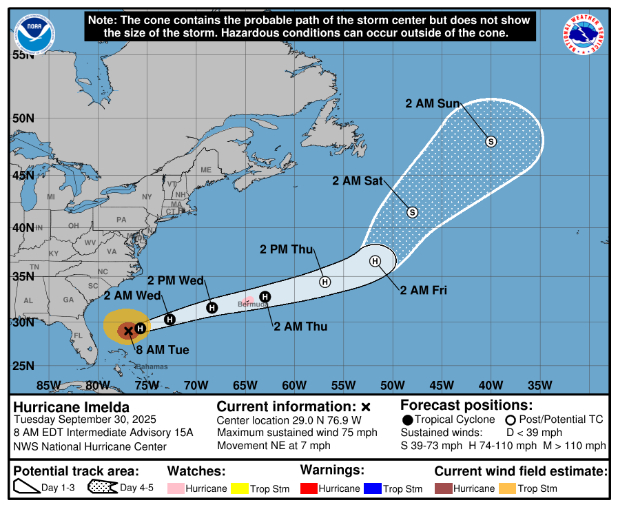
On September 30, Tropical Storm Imelda is moving northeast offshore of the U.S. East Coast, with forecasts showing it could become a hurricane near Bermuda. While landfall in the U.S. is not expected, Imelda’s outer rainbands may bring gusty winds and showers to the Southeast. Swells from both Imelda and Hurricane Humberto will continue to generate dangerous surf and rip currents along Atlantic beaches. The Gulf of America and Caribbean remain quiet.

Imelda gaining strength; turns away from U.S. coast; Humberto remains offshore
Atlantic Basin Overview
Hurricane Imelda
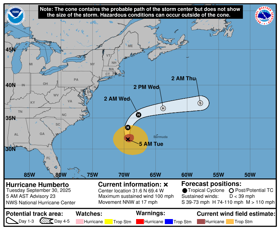
As of 5:00 AM EDT today, Imelda was centered near 28.8° N, 76.8° W, about 165 mi north of Great Abaco Island and 755 mi WSW of Bermuda.
Imelda is moving northeast at 7 mph and is expected to increase forward speed and turn toward the east-northeast tonight.
Imelda is now a hurricane.Hurricane Humberto & Other Waves
Humberto remains a strong system over the Atlantic and continues to generate swells that affect the U.S. East Coast.
Other Atlantic waves are being monitored, but none show imminent organization or clear paths toward land.
Hurricane Imelda


Hurricane Humberto


Environmental Conditions
Sea Surface Temperatures (SSTs): SSTs in Imelda’s path remain favorable for strengthening; as Imelda moves northeast, it will eventually encounter cooler waters which may begin to inhibit further intensification.
Wind Shear: Moderate shear persists around Imelda, which could slow down its deepening. As it moves further northeast, shear is expected to increase, limiting structural organization.
Humidity & Dry Air / SAL: Dry mid-level air and Saharan dust continue to intrude over parts of the Atlantic, suppressing convection especially in outer bands. These influences also hamper development of easterly waves farther out.
Gulf of America & Caribbean
The Gulf of America and the Caribbean remain calm, with no organized tropical systems currently developing.
Florida & Eastern U.S. Forecast
Florida & Southeast U.S.: The core of Imelda is forecast to remain offshore, turning away before making U.S. landfall. However, coastal and inland areas from Florida up through the Carolinas may experience gusty winds, showers, and elevated surf as Imelda passes east.
Marine Impacts: Swells and rough surf generated by Imelda (and Humberto) will continue to pose dangerous surf and rip current conditions along the Atlantic coast.
Rain forecast visualization courtesy of Windy.com
TL;DR – September 30 Snapshot
Imelda is strengthening, moving northeast, turning away from the U.S., with potential to become a hurricane near Bermuda.
Humberto remains offshore, continuing to generate swells along the East Coast.
SSTs support Imelda’s current growth; increasing shear and cooler waters will likely limit further intensification.
Gulf and Caribbean remain stable and quiet.
Eastern U.S. coast should watch marine impacts, shower bands, and gusty winds from Imelda’s outer rainbands.