Atlantic Hurricane Outlook – September 22, 2025
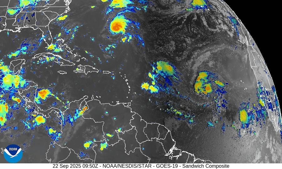
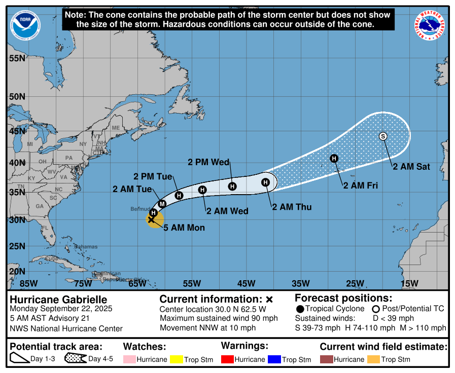
On September 22, Hurricane Gabrielle is active in the central Atlantic as a Category 1 storm with sustained winds near 90 mph. The storm is forecast to pass east of Bermuda, producing no direct land impacts but generating strong swells and rip currents. Two additional tropical waves are being monitored, with one given a 60% chance of development over the next week. Florida and the Gulf of America remain calm, experiencing only routine late-summer thunderstorms.

Hurricane Gabrielle strengthens; two additional waves being monitored
Atlantic Basin Overview
Hurricane Gabrielle
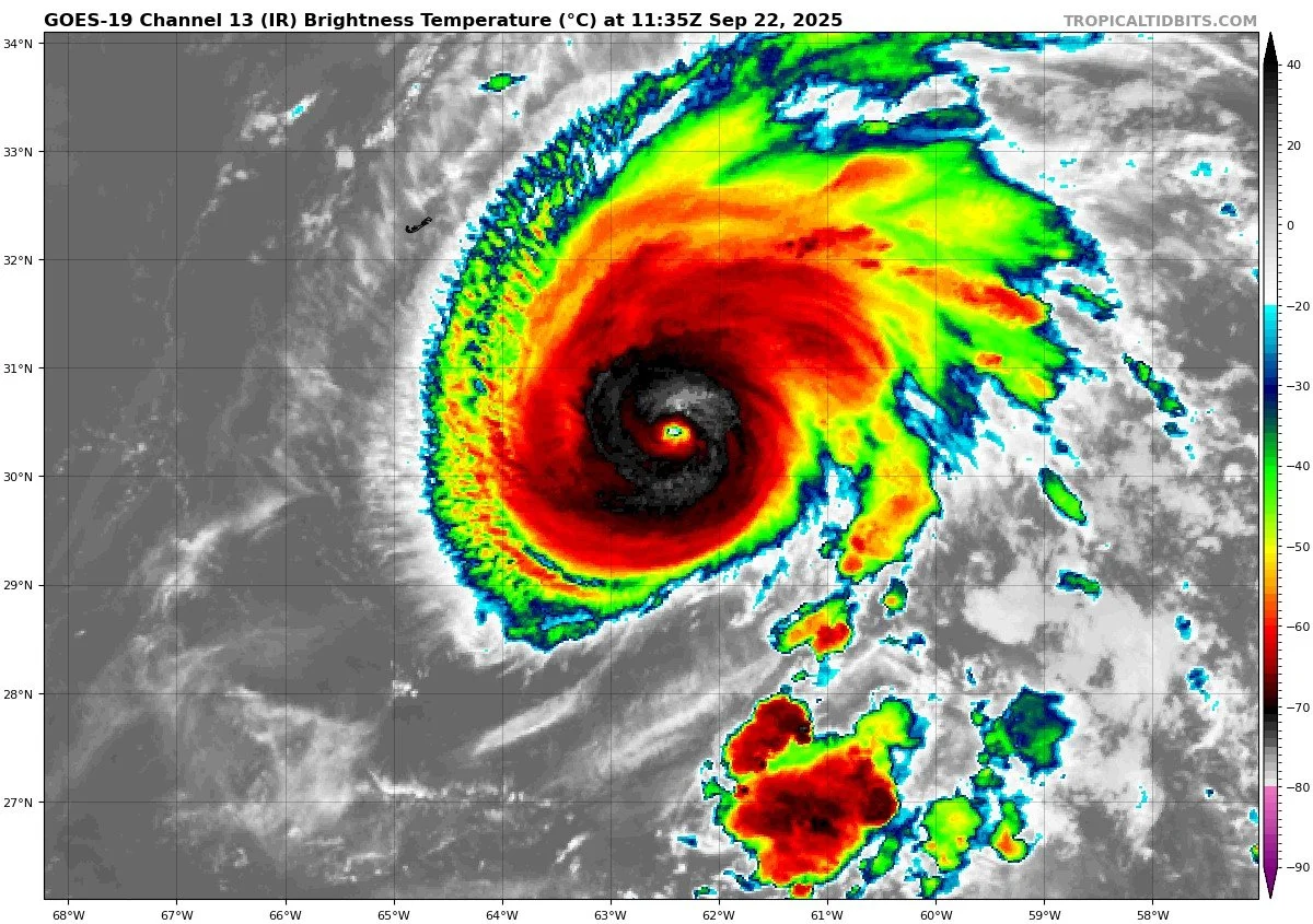
Gabrielle has intensified into a Category 1 hurricane, currently located southeast of Bermuda. Sustained winds are near 90 mph, and the storm is moving north-northwest at about 10 mph. Forecasts suggest further strengthening is possible over the next day or two. On its current track, Gabrielle is expected to pass east of Bermuda, with no direct landfall threat at this time.


Other Tropical Waves / Disturbances
The National Hurricane Center is monitoring two tropical waves across the Atlantic. One has a 60% chance of development over the next 7 days. Current model guidance suggests both systems are likely to stay over open waters or curve northward before approaching the Eastern U.S. coastline, including Florida, the Carolinas, and the Mid-Atlantic.
At this stage, no direct impacts are expected along the Eastern Seaboard, though stronger swells could increase rip current risks later in the week.
Environmental Conditions
Sea Surface Temperatures (SSTs): SSTs in the central to western tropical Atlantic remain warm—sufficient to support further strengthening of Gabrielle.
Wind Shear: Wind shear and dry air (including influence from the Saharan Air Layer) are suppressing organization in some quadrants of Gabrielle, slowing structural improvement.
Eastern Waves: The waves being monitored farther east are in less favorable environments currently—strong shear, dry air, and reduced moisture are limiting immediate development.
Gulf of America & Caribbean
The Gulf of America and Caribbean remain calm. High pressure dominates, producing only scattered afternoon thunderstorms. No organized tropical development is expected in these regions.
Florida & Eastern U.S. Forecast
Florida and the broader Eastern U.S. coastline remain outside of any direct tropical threats from Gabrielle or the monitored waves. Expect late-September conditions: warm, humid, with scattered afternoon thunderstorms. Swells from Gabrielle could enhance surf and rip current risks along parts of the East Coast later this week.
Rain forecast visualization courtesy of Windy.com

Summary
Gabrielle is now a Category 1 hurricane, strengthening in the central Atlantic, forecast to pass east of Bermuda.
Two tropical waves have been flagged; one has 60% development odds over 7 days, though no U.S. impacts are expected at this time.
Environmental factors favor Gabrielle’s gradual strengthening but suppress development of the eastern waves.
Gulf of America, Florida, and the Eastern Seaboard remain calm, with no direct tropical threats currently.
TL;DR – September 22 Snapshot
Hurricane Gabrielle is a Category 1, staying offshore and east of Bermuda.
Two waves being monitored; one with 60% odds, no U.S. threat expected.
Warm SSTs support Gabrielle; wind shear, dry air, and SAL limit other development.
Florida and the Eastern U.S. coast remain safe for now, aside from potential rip current risks.