Atlantic Hurricane Outlook – September 25, 2025
On September 25, Hurricane Gabrielle is weakening as it moves east toward the Azores, where hurricane conditions are expected. Meanwhile, Tropical Storm Humberto and Invest 94L are being monitored across the Atlantic, though neither currently threatens Florida or the Eastern Seaboard. Environmental factors—including wind shear, dry air, and Saharan dust—are limiting development. Florida and the Gulf of America remain quiet, with only routine late-summer storms.

Gabrielle weakening, approaching Azores; Humberto and 94L monitored in the Atlantic
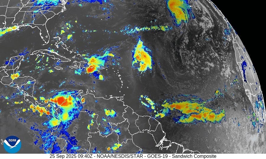
Atlantic Basin Overview
Hurricane Gabrielle
Gabrielle continues racing eastward toward the Azores under a hurricane warning. As of the latest advisory, it is located near 36.5°N, 38.8°W, moving due east at about 32 mph (28 kt), with sustained winds near 85 mph (75 kt). It is expected to bring hurricane conditions to the Azores tonight into early Friday. Afterward, Gabrielle is forecast to begin extratropical transition, weakening as it moves across cooler waters.Other Systems: Humberto & Invest 94L
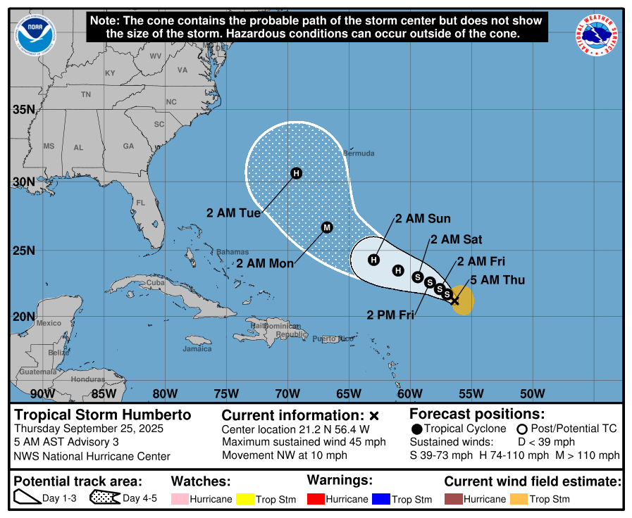
• Tropical Storm Humberto (previously Invest 93L) is being tracked in the Atlantic. It is not currently expected to threaten Florida or the Eastern U.S., with projected paths curving away.
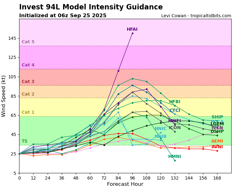
• Invest 94L, near the Caribbean / Dominican Republic area, is showing disorganized convection and has development potential in the next several days under favorable conditions.
Tropical Storm HUMBERTO
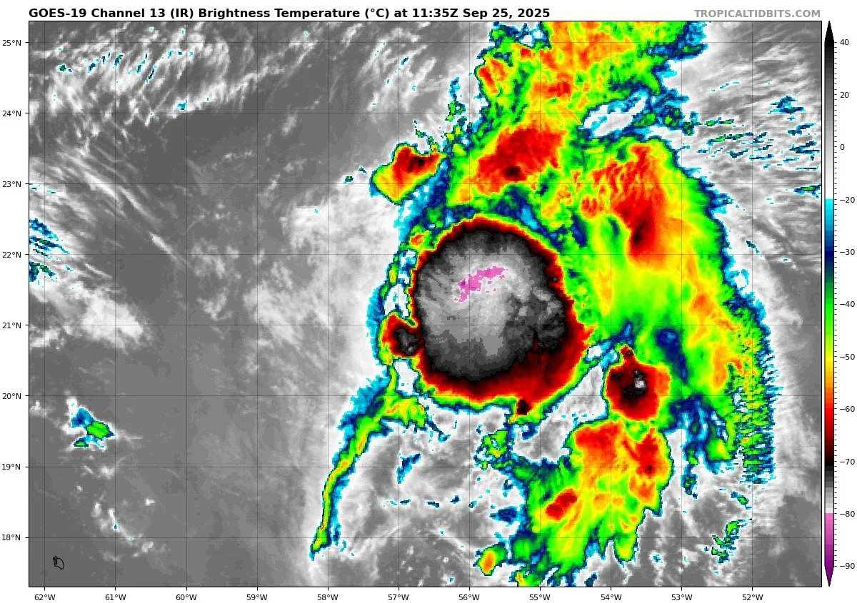


Invest 94L


Environmental Conditions
Sea Surface Temperatures (SSTs): SSTs along Gabrielle’s path remain warm, but cooler waters loom ahead; as it moves northeast, subsurface heat will diminish.
Wind Shear: Gabrielle is increasingly affected by stronger upper-level westerly shear, which is eroding its convective structure and will help accelerate its weakening.
Humidity & Dry Air / SAL: Dry mid-level air and influences from the Saharan Air Layer continue to disrupt convection, especially for the eastern systems. This is dampening the organization of Invest 94L and limiting intensification.
Gulf of America & Caribbean
The Gulf of America and Caribbean remain in a quiet pattern. No tropical systems are currently forming there. Typical late-September showers and thunderstorms are expected, with no signs of organized tropical development.
Florida & Eastern U.S. Forecast
Florida and the broader Eastern U.S. are outside the path of Gabrielle and other systems. No direct tropical threats are expected. The main hazard along the East Coast is dangerous surf and rip currents due to Gabrielle’s swell. Inland Florida continues with hot, humid conditions and scattered afternoon storms.
Rain forecast visualization courtesy of Windy.com

Summary
Gabrielle is weakening and moving toward the Azores, with hurricane conditions expected tonight.
Humberto and Invest 94L are being monitored; Humberto remains offshore, Invest 94L has potential but is disorganized.
Environmental factors: warm SSTs support Gabrielle, but increasing wind shear and dry air are weakening it; eastern systems face harsher conditions.
The Gulf of America, Caribbean, Florida, and Eastern Seaboard remain free from direct tropical threats, though marine hazards are present off the coast.
TL;DR – September 25 Snapshot
Gabrielle: eastward toward Azores, weakening, but still dangerous for those islands.
Humberto and Invest 94L are being watched, but not threatening Florida currently.
Warm waters vs. increasing shear and dry air shape evolution.
Florida & Gulf remain calm; East Coast surf/rip currents remain a hazard.