
Atlantic Hurricane Outlook – August 18, 2025Hurricane Erin re-strengthens to Category 4
Hurricane Erin has regained Category 4 strength east of the Bahamas, bringing life-threatening surf and rip currents along the East Coast. While the U.S. mainland is safe from direct impacts, evacuations are underway in the Outer Banks. Gulf and Florida conditions remain quiet with only routine storms.

TLDR Version; Click Here
Hurricane Erin re-strengthens to Category 4; East Coast braces for powerful surf and rip currents
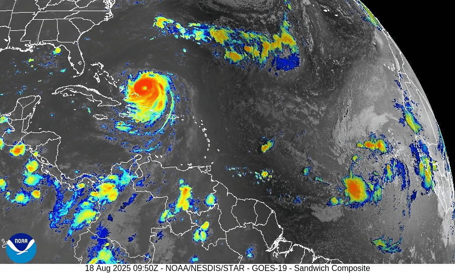
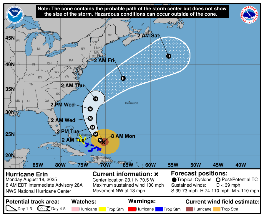
Hurricane Erin has re-intensified into a Category 4 storm, centered roughly 100 miles east of Turks and Caicos and the southeastern Bahamas. The U.S. mainland remains out of Erin’s direct path, but life-threatening surf, erosion, and coastal flooding are expected along the Eastern Seaboard. Meanwhile, a separate Atlantic disturbance now carries a 50% chance of tropical development later in the week. No tropical threats currently exist for the Gulf or Florida.
Atlantic Basin Overview
Hurricane Erin (Cat 4): Sustained winds are around 130 mph, with tropical-storm-force winds extending up to 230 miles from the center. A tropical storm warning is in effect for the Turks and Caicos and the southeastern Bahamas, while a tropical storm watch is in place for the central Bahamas.
Coastal Threats: The Outer Banks of North Carolina, including Hatteras Island, face mandatory evacuations due to expected high surf and coastal flooding—even without landfall. Wave heights may reach 20 ft, especially during high tides, while Bermuda could see even larger 25–30 ft waves. Rip current risk is moderate to high, spreading across East Coast beaches.
Other Atlantic Activity: A new disturbance in the eastern Atlantic now has a 50% chance of becoming tropical within 7 days. It’s forecast to approach the Lesser Antilles later this week, potentially enhancing rain and wind there.
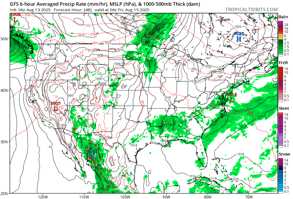
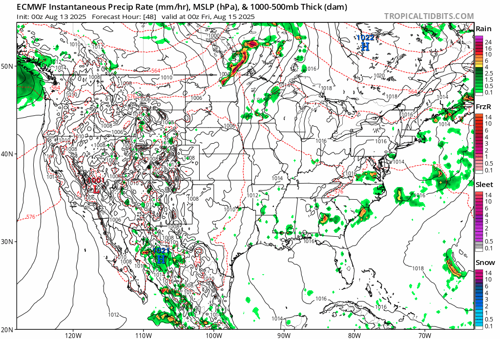
We’re monitoring this new low-pressure system that is trailing Erin. Preliminary models are showing a similar path to Erin, but closer to the US Coastline. This could change drastically in the next several days.


Potential for organization in Red Circle - ECMWF Model
Potential for organization in Red Circle - GFS Model
Gulf of America (Mexico) & Caribbean
Gulf: No tropical development is anticipated. A lack of organized circulation and moderate shear conditions minimizes the likelihood of new cyclogenesis.
Caribbean Sea: Active only in the context of Erin—no other systems are currently being monitored.
Florida & Southeast U.S. Forecast
Florida: Expect typical mid-August weather—hot with daily afternoon showers and storms, especially inland. No tropical impacts are expected.
East Coast Beaches: Prepare for increasing surf, coastal erosion, and hazardous rip currents beginning midweek as swells from Erin arrive. Beaches without lifeguards pose significant dangers.
Rain forecast visualization courtesy of Windy.com
Environmental Conditions (Why Erin Strengthens)
Sea Surface Temperatures (SSTs): Still in the high 80s °F (near 30 °C) across the Atlantic, providing ample heat for Erin’s sustainment.
Wind Shear: Still moderate but trending downward near Erin’s path, facilitating its re-strengthening to Category 4.
Dry Air/Saharan Dust: Continues to affect waves farther east, suppressing development elsewhere; Erin’s size and organization now buffer these effects.

Preparedness Summary
Erin stays over open water but poses significant marine and coastal hazards—especially in the Outer Banks and along the East Coast.
Evacuations in place for vulnerable coastal locations such as Hatteras Island.
Florida and Gulf regions remain free from direct tropical threats—just routine summer storms.
Beachgoers: Avoid swimming where there are no lifeguards. Monitor local advisories for surf and rip current warnings.
TL;DR – August 18 Snapshot
Hurricane Erin strengthens back to Category 4 offshore; dangerous surf and rip currents expected along East Coast.
Eastern Atlantic wave may develop; 50% development odds in coming days.
Gulf and Florida remain quiet with no tropical threats.
Coastal communities, especially in NC, should act on evacuation orders and heed marine hazard alerts.
Atlantic Hurricane Outlook – August 16, 2025: Erin intensifies over the central Atlantic
Hurricane Erin has intensified over the central Atlantic while a weak Gulf disturbance delivers rain to South Texas and NE Mexico. Florida sees typical summer storms, with rising rip-current risks along Atlantic beaches as Erin’s swells arrive.
TLDR Version; Click Here

Erin intensifies over the central Atlantic; weak Gulf disturbance keeps rain focused on far South Texas and NE Mexico; U.S. impacts mainly marine
Hurricane Erin has strengthened over the central tropical Atlantic and remains on a track that keeps it well offshore of the U.S. mainland. In the Gulf of Mexico, a weak, broad low near the Bay of Campeche continues to funnel tropical moisture into far South Texas and northeastern Mexico, with low odds of tropical development. For most U.S. coastlines, the primary near-term impacts are building surf and an elevated rip-current risk as Erin’s long-period swells arrive.
Atlantic Basin Overview
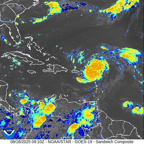
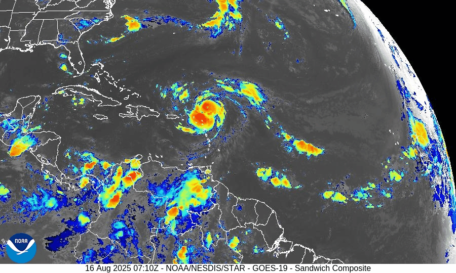
Hurricane Erin (central Atlantic): Erin has intensified into a major hurricane over very warm waters with supportive upper-level ventilation. Forecast guidance continues to favor a gradual bend to the northwest and then north this weekend into early next week, keeping the core well away from the Bahamas and U.S. East Coast. Even with an offshore track, long-period swells will propagate toward the Western Atlantic shorelines, bringing hazardous surf and rip currents ahead of any weather changes locally.
Elsewhere in the basin: A typical mid-August “wave train” extends from Africa across the Main Development Region (MDR). Most waves are battling pockets of dry air/Saharan dust and intermittent mid- to upper-level shear, limiting organization in the short term.


Gulf of America (Mexico) & Caribbean
Southwest Gulf disturbance (Bay of Campeche): A broad trough/weak low continues to drift west-northwest toward northeastern Mexico. Organization is limited; development odds remain low. Regardless of development, expect periods of heavy rain, locally gusty squalls, and choppy seas from the lower Texas coast southward into Tamaulipas/Veracruz.
Rest of the Gulf: Typical summer regime with scattered sea-breeze thunderstorms near the margins; light to moderate onshore flow most areas, with evening pulses of fresh easterlies along the Yucatán coast.
Caribbean Sea: Fresh trades continue in the south-central Caribbean with passing showers; no organized tropical systems at this time.
Florida & Southeast U.S. Outlook
Florida (statewide): A classic August pattern—hot, humid, and scattered to numerous afternoon thunderstorms driven by sea-breeze collisions and outflow boundaries. Storms are not tropical in origin but can produce frequent lightning, brief torrential rain, and localized gusty winds.
Atlantic beaches (FL/GA/SC/NC): Expect a rising rip-current risk and building surf through the weekend into early next week as Erin’s swells arrive. Check local beach forecasts and heed lifeguard guidance.
Gulf beaches (FL Panhandle/West FL): Typical late-day storms; rip-current risk mainly tied to local winds and storm outflows rather than distant swell.
Rain forecast visualization courtesy of Windy.com
Environmental Setup (Why/Why Not Development)
Sea Surface Temperatures: MDR, Caribbean, and Gulf waters are well above seasonal averages, supplying ample oceanic heat content (fuel) for systems that find a favorable atmospheric window.
Wind Shear: Shear is comparatively lower along Erin’s corridor (supporting its intensification) but patchy and occasionally moderate to high elsewhere—enough to disrupt other waves.
Moisture & SAL: Mid-level moisture is increasing west of ~45–50°W, but Saharan Air Layer intrusions still clip portions of the eastern/central MDR, injecting dry air and capping convection for several waves.
Preparedness Note

Even when a hurricane stays far offshore, its swells can be dangerous. If you’re heading to the beach, swim near lifeguards, avoid jetties/inlets during high surf, and review local rip-current statements. For Gulf communities under heavy rain today, avoid flooded roadways and allow extra travel time.
TL;DR – August 16 Snapshot
Erin is a major hurricane over the central Atlantic; expected to turn north and remain offshore of the U.S.
Bay of Campeche disturbance: Low development odds; brings heavy rain to far South Texas and NE Mexico.
Florida & Southeast: Typical hot, stormy afternoons; rip-current risk rising on Atlantic beaches from Erin’s distant swells.
Overall Atlantic remains active with waves, but shear and dry air are limiting most systems—for now.
Atlantic Hurricane Outlook – August 13, 2025: Erin Expected to Become 2025’s First Major Hurricane; U.S. Coast Still Unthreatened
Tropical Storm Erin is gaining strength in the Atlantic and could reach major hurricane status this weekend. Forecasts keep it well offshore, but the Southeast coast will see increasing surf and rip currents. Gulf and Florida remain quiet.
A couple disturbances being monitored along with TS Erin
TLDR Version: Click Here
Tropical Storm Erin is continuing its westward progression across the eastern Atlantic, with strong model agreement that it will likely intensify into a major hurricane this weekend. While its path remains well east of the U.S., coastal regions should prepare for elevated surf and rip current risks in the coming days.
Atlantic Basin Overview
Tropical Storm Erin remains steady with sustained winds of 45 mph, moving west at 20 mph.
Forecasts now indicate Erin may become a Category 3 hurricane by Sunday, as environmental conditions improve.
Some models suggest Erin will pass north of the northern Leeward Islands, with a likely northwest turn before reaching the Bahamas—thereby minimizing direct U.S. impacts.
Meanwhile, Invest 96L and other tropical waves remain under observation, but Erin is the dominant system for now.


Gulf of America (Mexico) & Caribbean Conditions
Gulf of America (Mexico): Calm and quiet. Sea surface temperatures are approximately 2°F above average, creating favorable conditions—but without current disturbances.
Caribbean Sea: Trade winds and typical convection dominate. No organized systems at this time.
GOES - GULF - Sandwich - August 13, 2025
GOES - Caribbean - Sandwich - August 13, 2025
Florida & Southeast Outlook
Forecast: Expect hot, humid conditions with typical afternoon sea-breeze thunderstorms. These are non-tropical and not linked to Erin.
Marine Hazards: Elevated surf and dangerous rip currents are becoming a concern along the Southeast coast due to Erin’s offshore activity.
Rain forecast visualization courtesy of Windy.com
Looking Ahead & Preparation
Erin is on track to intensify significantly but should remain well offshore through the weekend.
Continue watching Invest 96L and subsequent waves for potential tropical development.
Residents along the Southeast coast should prepare for marine hazards—not wind or rain threats at this stage.
TL;DR – August 13 Snapshot
Erin is strengthening—expected to become 2025’s first major hurricane.
Forecast track keeps it east of the U.S. mainland.
Gulf and Florida remain calm, with routine summer weather.
Watch for increasing surf and rip current hazards along the Eastern Seaboard.
Stay informed with daily updates on Cat5Prep.