
Atlantic Hurricane Outlook – October 5, 2025
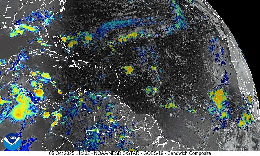
On October 5, a tropical disturbance in the central Atlantic is showing improved organization and now carries a 70% chance of development according to the National Hurricane Center. The system may become a tropical depression or storm early this week as it moves west-northwest across warm waters. Imelda’s remnants continue to fade, and the Gulf of America and Florida remain quiet aside from minor marine impacts.

Tropical disturbance in central Atlantic gains strength; 70% development chance in coming days
Atlantic Basin Overview
Invest Area – Central Atlantic Disturbance (High Chance of Formation)
The National Hurricane Center is closely monitoring a well-defined tropical wave located in the central tropical Atlantic, roughly halfway between the Cabo Verde Islands and the Lesser Antilles.The system has shown improving organization over the past 24 hours with:
• Persistent clusters of deep convection.
• Increasing low-level rotation visible in satellite imagery.
• A pocket of lighter wind shear and higher mid-level humidity supporting development.The NHC now gives this system a 70% chance of tropical cyclone formation within 7 days, and it may become a tropical depression or storm early this week as it moves west-northwest at 10–15 mph across warm 29–30 °C waters.
Long-range model guidance suggests the system will stay well east of the Caribbean for the next 5 days, though trends bear monitoring.
Post-Tropical Imelda
Imelda remains a strong post-tropical cyclone over the open Atlantic. It is racing east-northeast and poses no threat to land, though it continues to generate residual swell and rough seas over parts of the North Atlantic.Other Waves / Disturbances
No additional organized systems are present. A weak wave emerging from western Africa remains broad and disorganized under dry air.

Environmental Conditions
Sea Surface Temperatures (SSTs):
SSTs across the central and western tropical Atlantic remain above average (29–30 °C), easily supportive of development if convection persists.Wind Shear:
The disturbance lies in a localized pocket of lower shear (10–15 kt), which is helping convection consolidate. Stronger shear farther west may slow development later in the week.Humidity & Dry Air / SAL:
The Saharan Air Layer (SAL) continues to influence the eastern Atlantic but has weakened around the current disturbance. Improved mid-level moisture is aiding its gradual organization.
Gulf of America & Caribbean
The Gulf of America and Caribbean remain calm with no tropical systems expected. Daily thunderstorms continue in typical early-October fashion.
Florida & Eastern U.S. Forecast
There are no immediate tropical threats to Florida or the Eastern U.S. at this time.
The ongoing Atlantic disturbance is far east of the region and poses no short-term risk. Coastal conditions remain influenced by lingering swell energy from Imelda, producing rough surf and rip currents along Atlantic beaches.
Rain forecast visualization courtesy of Windy.com
TL;DR – October 5 Snapshot
A tropical disturbance in the central Atlantic has a 70% chance of development over the next 7 days.
The system is expected to move west-northwest, staying well east of the Caribbean in the short term.
Imelda remains post-tropical and no longer a threat.
Environmental factors — warm SSTs, low shear, and improved moisture — favor gradual development.
Florida and the Gulf of America remain quiet, with marine impacts limited to elevated surf and rip currents.