
Atlantic Hurricane Outlook – August 9, 2025: Quiet Tropics with More Waves Brewing
Tropics stay quiet as Invest 96L weakens, but a fresh African wave is gaining attention with a 30% development chance in the next week. Peak season conditions are setting up.
*TLDR Version, Jump Here!
The Atlantic remains calm, but early signs indicate a potential ramp-up in activity. One tropical wave is weakening, while another emerging off Africa is attracting attention due to improving environmental conditions.
Atlantic Basin Overview
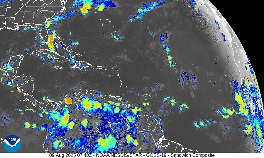
Invest AL96 (Central Atlantic):
The tropical wave associated with AL96 has seen its convection collapse in recent days, largely due to dry, Saharan-influenced air. Development chances remain low at 0–2 days, though gradual organization may become possible in the middle of next week as the system moves northwestward .New African Tropical Wave:
A fresh tropical wave just exiting the African coast has been designated an area of interest. The NHC currently assigns a 30% chance of development over the next 7 days. Long-range models depict a perhaps more favorable environment, suggesting potential development beyond a week and possible impacts in the eastern Caribbean around August 16–17.
Possible hurricane development in the Caribbean newest Tropical Wave. Forecast for around August 20, 2025
Key Environmental Conditions
Seasonal Shift Underway:
Climatologically, the Atlantic heads into its most active phase by mid-August. Increased sea surface temperatures, decreasing wind shear, and waning Saharan dust set the stage for heightened storm activity.
Dust & SAL data from Windy.com
Florida & Coastal Outlook
No threats to land are expected over the next 10 days—including Florida and the continental U.S.—according to current tropical storm patterns and long-range models.
Ripple Effects: Though storm formation is uncertain, increased attention should be paid to rip currents and surf conditions as system trajectories evolve.
Rain forecast visualization courtesy of Windy.com
TL;DR – August 9 Snapshot
Invest 96L: Diminishing convection now, slight development possible later next week.
African wave: 30% chance of forming in 7 days; more model support for mid- to late-August activity.
Environment: Conditions are trending more favorable—very warm waters, less dust, easing shear.
Threat to U.S.: None imminent, but upward trend in activity expected ahead.
Stay alert. Peak season is building fast. Visit CAT5Prep.com for updates.

Atlantic Hurricane Outlook – August 5, 2025: Dexter Weakening, Two Other Areas Monitored
Tropical Storm Dexter weakens far from land, while two other systems—one off Africa and one near the Southeast U.S.—are being watched. Although development chances remain modest, conditions are expected to become more favorable later this month.
Tropical Storm Dexter is slowly weakening but not yet dissipated, while two additional disturbances now carry up to a 30–50% chance of development within the next week. Environmental conditions remain a limiting factor for most areas, but shift slowly toward greater activity as August progresses.
Atlantic Basin Summary
Tropical Storm Dexter
Located roughly 250–275 miles north-northwest of Bermuda, Dexter has maximum sustained winds near 45 mph and is moving northeast at ~12–15 mph. While it is weakening, it may reintensify as a post-tropical cyclone late this week, posing no direct land threat.
Other Areas Under Watch
A low-pressure area offshore of the Southeast U.S. (Invest AL95) carries a 30% chance of development over 7 days. Slight organization is possible as it moves eastward, but land impacts are unlikely.
A tropical wave near ~30°W off Africa shows scattered convection and is assigned a 50% chance of development within 7 days, reflecting improving model support.
Key Environmental Conditions
*In the upper right corner of the below screens, toggle with the +/- icons
Sea Surface Temperatures (SSTs):
Gulf of Mexico, Caribbean, and MDR waters range between 29–31 °C (84–88 °F)—ample heat energy for storm formation if atmospheric conditions cooperate.Wind Shear:
Wind shear remains moderate to high across much of the Atlantic, especially in the central basin, limiting storm organization despite occasional lower-shear pockets emerging near the western Gulf.Saharan Air Layer (SAL):
A large SAL plume continues across the eastern and central Atlantic. Its dry, dusty air suppresses convection and hampers the vertical growth of tropical disturbances.Moisture:
While mid-level humidity is increasing over the western tropical Atlantic, SAL and shear are keeping much of the central MDR too dry for sustained thunderstorm development.
Gulf of America (Mexico) & Caribbean Overview
No disturbances are currently being monitored.
A stationary front and ridge of high pressure maintain light to moderate winds and calm seas across the Gulf and Caribbean.
Scattered showers remain typical for early August and are not linked to tropical systems.
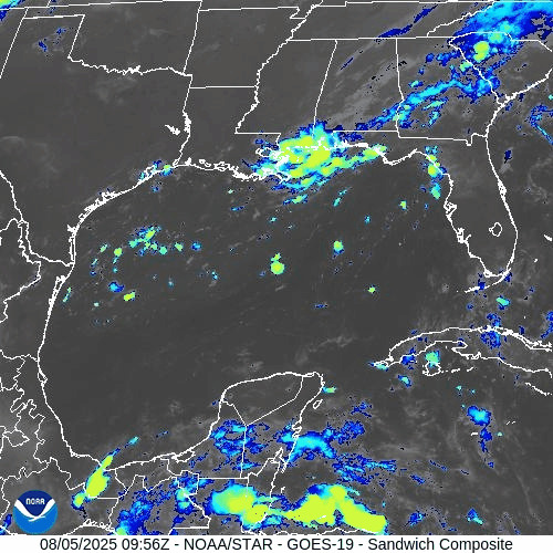
GOES-19 - Sector view: Gulf
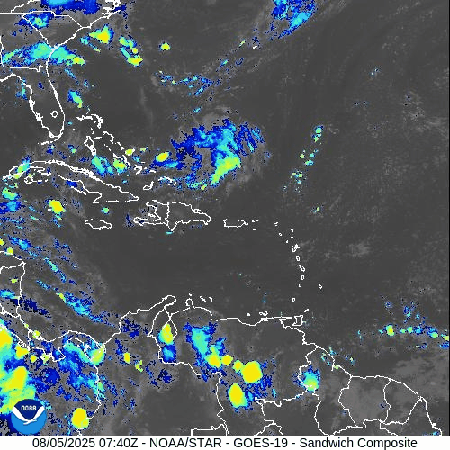
GOES-19 - Sector view: Caribbean
Florida Forecast
Highs: Near 90 °F with high humidity.
Afternoon thunderstorms: 40–50% chance from sea breeze activity.
Winds: Light and variable inland, shifting southeast near the coast.
No tropical storm impacts are expected today.
Rain forecast visualization courtesy of Windy.com
Prep Tip of the Day
Make sure your alert systems are working and up-to-date: test county-level emergency alerts, NOAA weather radios, and storm tracking apps. Confirm evacuation plans with household members and review where supplies are stored.
Outlook
Dexter poses no threat to land, but the tropical wave near Africa and Invest off the U.S. Southeast coast warrant close attention. August is historically when activity ramps up; conditions may become more favorable later in the week.
TL;DR – August 5 Snapshot
Tropical Storm Dexter weakening, drifting north but may reintensify offshore.
Two areas monitored: AL95 (30% chance) and African wave (~50% chance) for potential development.
SSTs remain warm, but SAL and wind shear continue to suppress many systems.
No tropical threats to Florida today—just typical summer storms.
Expect activity to increase as August progresses.
Stay ready and informed with daily updates at Cat5Prep.com.