
Atlantic Hurricane Outlook – July 14, 2025: Gulf Disturbance Signals Season’s Shift
A weak trough near Florida could organize as it moves into the Gulf of Mexico this week. While not yet a named system, heavy rain and flooding may impact Florida and Gulf Coast states. Stay informed and prepared.
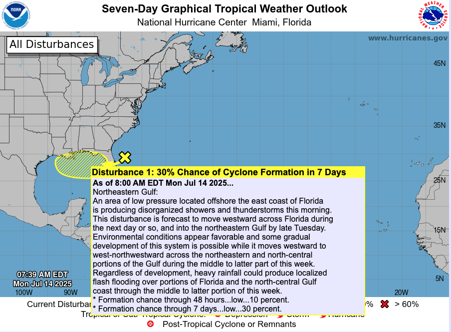
The Atlantic basin remains mostly calm, but the tropics are waking up. A trough of low pressure is moving off the Southeast U.S. coast and entering the Gulf of Mexico, where it's now being monitored for potential tropical development later this week.
Atlantic Basin: Early Signs of Activity
No named tropical cyclones currently.
The trough is producing disorganized clouds and showers along the Southeast coast and across Florida.
According to the NHC, this system has about a 30% chance of organizing into a tropical depression or storm over the next seven days, with a 10% chance in 48 hours.
If it develops, it could move west across the Gulf toward Louisiana and Texas by late week.
Satellite view via Windy.com
Foundation: Ocean & Atmosphere Basics
Sea Surface Temperatures (SSTs) are 2–4°F above average in the Gulf, Caribbean, and Main Development Region—providing the warm fuel needed for development.
Sea Surface Temperature via Windy.com

Wind Shear Courtesy of https://tropic.ssec.wisc.edu/
Wind shear remains moderate-to-strong across much of the basin; however, conditions in the northeastern Gulf may become more favorable for storm organization.
Saharan dust continues to suppress development in the eastern Atlantic, but this trough is well west of that region.
Saharan Air Layer (Dust) via Windy.com
Local Weather: Rain and Thunderstorms Ahead
Florida: Expect multiple rounds of heavy rain and thunderstorms today through Wednesday as the trough crosses the peninsula.
Gulf Coast (AL, MS, LA, TX): Showers, thunderstorms, and flooding potential increase by mid-to-late week.
Attention zones: Tampa, Orlando, Dolphins could see over 6″ of rain; Houston and Mobile might experience heavy downpours and gusts.
Thunderstorm Forecast (ECMWF) via Windy.com
Prep Tip: Heavy Rain Trumps Wind Now
With flooding as the primary threat:
Ensure your home’s drainage systems are clear.
Prepare sandbags and supplies if you live in low-lying or flood-prone zones.
Keep flashlight, battery-powered radio, and emergency kits on hand.
Continue monitoring NOAA Weather Radio and local alerts as storms advance.
Looking Ahead: Watch This Week Carefully
As the trough moves into the Gulf, developing into a tropical depression or storm is possible.
Even without full tropical development, heavy rain and localized flooding pose a risk to the Southeast U.S. and Gulf states.
This activity could become the season’s first system to affect U.S. mainland—track it closely over the next 3–7 days.
Stay tuned to Cat5Prep.com for your next daily update—this season may be shifting right before our eyes.