
Decoding Hurricane Forecasts: Mastering the Tropical Weather Outlook and Forecast Cone
Introduction: The Consequences of Misinterpretation
In August 2022, as Hurricane Ian approached Florida, many residents in Lee County felt a false sense of security. The early forecast cones suggested the storm would veer north, sparing their area. However, Ian shifted southward, making landfall near Fort Myers and causing catastrophic damage. This tragic event highlighted a critical issue: misunderstanding hurricane forecasts can lead to dire consequences.
To make informed decisions during hurricane season, it's essential to understand the tools meteorologists use to communicate storm information. Two primary resources are the Tropical Weather Outlook (TWO) and the Forecast Cone. Let's delve into these tools, learn how to interpret them accurately, and explore how professionals analyze them.
Section 1: Understanding the Tropical Weather Outlook (TWO)

What Is the TWO?
The Tropical Weather Outlook is a text and graphical product issued by the National Hurricane Center (NHC) that provides information on potential tropical cyclone development over the next five days. It's updated four times daily at 2 AM, 8 AM, 2 PM, and 8 PM EDT during hurricane season (June 1–November 30). https://www.nhc.noaa.gov/
Key Components of the TWO
Disturbance Identification: Each potential system is labeled with a number (e.g., "Disturbance 1") and marked with an "X" on the map.
Development Potential: The TWO assigns a color code to each disturbance indicating the likelihood of cyclone formation:
Yellow: Low chance (<40%)
Orange: Medium chance (40–60%)
Red: High chance (>60%)
Discussion Text: A brief narrative describes the disturbance's current state, environmental conditions, and potential for development.
How Professionals Interpret the TWO
Meteorologists analyze the TWO to assess the potential for tropical cyclone formation. They consider factors like sea surface temperatures, wind shear, and atmospheric moisture. A disturbance with a high chance of development in a conducive environment warrants closer monitoring and potential early preparation.
Example: Interpreting a TWO Graphic
In this example, "Disturbance 1" is marked with a yellow "X," indicating a low chance of development. The accompanying text explains that it is expected to move inland and the chance of it developing into a subtropical or tropical cyclone is near zero. However, heavy rainfall may cause flash flooding along parts of the southeastern U.S. coast today and tomorrow, since this is actually today’s graph. (June 4, 2025)

Section 2: Deciphering the Forecast Cone
What Is the Forecast Cone?
What Is the Forecast Cone?
The Forecast Cone, often referred to as the "Cone of Uncertainty," is a visual tool produced by the National Hurricane Center (NHC) that shows the probable path of the center of a tropical cyclone over the next 3 to 5 days.
It is constructed around the NHC's official forecast track, with the cone's width at each time interval based on historical average track errors. This means the storm’s center is expected to remain within the cone about 60–70% of the time, but hazardous weather can occur far outside of it.
The cone does not indicate the size of the storm or the extent of its impacts—it only reflects the expected path of the storm's center and the uncertainty in that forecast as time increases.
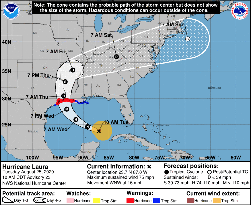
Key Elements of the Forecast Cone
Current Storm Position: Indicated by a black "X" on the map.
Forecast Track: A line of black dots shows the predicted center positions at 12-hour intervals.
Cone Shape: The cone widens over time, reflecting increasing uncertainty in the forecast.
Intensity Indicators: Letters within the forecast dots denote the storm's expected intensity:
D: Tropical Depression
S: Tropical Storm
H: Hurricane
M: Major Hurricane
Watches and Warnings: Colored areas along the coast indicate active advisories:
Red: Hurricane Warning
Pink: Hurricane Watch
Blue: Tropical Storm Warning
Yellow: Tropical Storm Watch
WATCH = Be Prepared / Conditions are POSSIBLE WARNING = Take Action / Conditions are EXPECTED
Common Misconceptions
"I'm Safe Outside the Cone": The cone only predicts the storm's center path, not the extent of hazardous conditions. Dangerous winds, heavy rain, and storm surge can occur far outside the cone.
"The Cone Shows the Storm's Size": The cone doesn't represent the storm's size or impact area. It's solely about the projected path of the center.
How Professionals Analyze the Forecast Cone
Forecasters consider the cone as one piece of the puzzle. They also examine wind field graphics, rainfall forecasts, and storm surge models to assess potential impacts. Understanding the cone's limitations is crucial for accurate risk assessment.
Example: Reading a Forecast Cone

In this graphic, the storm is currently a major hurricane ("M”) and was forecasted to be downgraded to a hurricane ("H") within 5 days. The cone widens over time, indicating increased uncertainty. Coastal areas within the red zone are under a hurricane warning, signalling imminent hazardous conditions.
Section 3: Integrating the TWO and Forecast Cone
By combining information from the TWO and the Forecast Cone, you can gain a comprehensive understanding of a storm's potential development and trajectory. For instance, if the TWO indicates a high chance of development for a disturbance, and subsequent forecasts place it within a cone that includes your area, it's time to prepare.
Section 4: Practical Tips for the Public
Stay Informed: Regularly check the NHC website for the latest TWO and Forecast Cone updates.
Understand the Tools: Learn what each graphic represents and its limitations.
Don't Rely Solely on the Cone: Consider other forecasts and advisories, such as wind speed probabilities and storm surge warnings.
Prepare Early: If your area is within or near the cone, begin preparations promptly.
Follow Official Guidance: Heed evacuation orders and other instructions from local authorities.
Knowledge Is Power
Understanding the Tropical Weather Outlook and Forecast Cone empowers you to make informed decisions during hurricane season. By interpreting these tools accurately, you can better protect yourself, your family, and your property from the devastating impacts of tropical cyclones.